
Make a donation
City of Cape Town topographic map
Click on the map to display elevation.
Make a donation
About this map
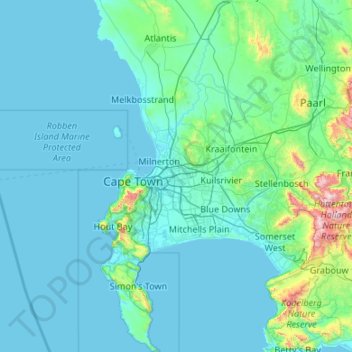
Name: City of Cape Town topographic map, elevation, terrain.
Location: City of Cape Town, Western Cape, South Africa (-46.98194 18.30722 -33.47128 38.00332)
Average elevation: 23 m
Minimum elevation: 0 m
Maximum elevation: 1,978 m
Make a donation
Other topographic maps
Click on a map to view its topography, its elevation and its terrain.
Cape Town
South Africa > Western Cape > City of Cape Town
The Cape Peninsula is 52 km long from Mouille Point in the north to Cape Point in the south, with an area of about 470 km2, and it displays more topographical variety than other similar sized areas in southern Africa, and consequently spectacular scenery. There are diverse low-nutrient soils, large rocky…
Average elevation: 53 m
Durbanville
South Africa > Western Cape > City of Cape Town
Durbanville is situated in the northern suburbs of Cape Town, approximately 28 kilometres (17.4 mi) north-east of the city, bordered by Bellville to the south, Brackenfell to the south-east and Kraaifontein to the east. It lies at an altitude of between 100 m (328 ft) to 240 m (787 ft), in the vast rolling…
Average elevation: 157 m
Stellenbosch
South Africa > Western Cape > Cape Winelands District Municipality > Stellenbosch Local Municipality
Stellenbosch is 53 km (33 mi) east of Cape Town via National Route N1. Stellenbosch is in a hilly region of the Cape Winelands, and is sheltered in a valley at an average elevation of 136 m (446 ft), flanked on the west by Papegaaiberg (Afrikaans: Parrot Mountain), which is actually a hill. To the south is…
Average elevation: 287 m
Make a donation
Cape Town
South Africa > Western Cape > City of Cape Town
The Cape Peninsula is 52 km long from Mouille Point in the north to Cape Point in the south, with an area of about 470 km2, and it displays more topographical variety than other similar sized areas in southern Africa, and consequently spectacular scenery. There are diverse low-nutrient soils, large rocky…
Average elevation: 53 m
Table Mountain
South Africa > Western Cape > City of Cape Town > Cape Town
Table Mountain is at the northern end of a sandstone mountain range that forms the spine of the Cape Peninsula that terminates approximately 50 kilometres (30 mi) to the south at the Cape of Good Hope and Cape Point. Immediately to the south of Table Mountain is a rugged "plateau" at a somewhat lower elevation…
Average elevation: 583 m
Great Karoo
South Africa > Western Cape > Central Karoo District Municipality > Beaufort West Local Municipality
Average elevation: 853 m
Make a donation
Velddrif
South Africa > Western Cape > West Coast District Municipality > Bergrivier Local Municipality
Average elevation: 8 m
Matroosberg
South Africa > Western Cape > Cape Winelands District Municipality > Witzenberg Local Municipality
Average elevation: 1,887 m
Tafelberg
South Africa > Western Cape > West Coast District Municipality > Cederberg Local Municipality
Average elevation: 1,526 m
Stellenbosch
South Africa > Western Cape > Cape Winelands District Municipality > Stellenbosch Local Municipality
Stellenbosch is 53 km (33 mi) east of Cape Town via National Route N1. Stellenbosch is in a hilly region of the Cape Winelands, and is sheltered in a valley at an average elevation of 136 m (446 ft), flanked on the west by Papegaaiberg (Afrikaans: Parrot Mountain), which is actually a hill. To the south is…
Average elevation: 222 m
Make a donation
Cape Town
South Africa > Western Cape > City of Cape Town
The Cape Peninsula is 52 km (30 mi) long from Mouille Point in the north to Cape Point in the south, with an area of about 470 km2 (180 sq mi), and it displays more topographical variety than other similar sized areas in southern Africa, and consequently spectacular scenery. There are diverse low-nutrient…
Average elevation: 53 m
Wellington
South Africa > Western Cape > Cape Winelands District Municipality > Drakenstein Local Municipality
Average elevation: 168 m
Make a donation
Aurora
South Africa > Western Cape > West Coast District Municipality > Bergrivier Local Municipality
Average elevation: 136 m
Franschhoek
South Africa > Western Cape > Cape Winelands District Municipality > Stellenbosch Local Municipality
Average elevation: 502 m
Make a donation
Hopefield
South Africa > Western Cape > West Coast District Municipality > Saldanha Bay Local Municipality
Average elevation: 58 m
Stellenbosch
South Africa > Western Cape > Cape Winelands District Municipality > Stellenbosch Local Municipality
Stellenbosch is 53 km (33 mi) east of Cape Town via National Route N1. Stellenbosch is in a hilly region of the Cape Winelands, and is sheltered in a valley at an average elevation of 136 m (446 ft), flanked on the west by Papegaaiberg (Afrikaans: Parrot Mountain), which is actually a hill. To the south is…
Average elevation: 222 m
Make a donation
Make a donation
Tulbagh
South Africa > Western Cape > Cape Winelands District Municipality > Witzenberg Local Municipality
Average elevation: 191 m
Mossel Bay
South Africa > Western Cape > George
To the east, the land slopes upwards towards the wave-cut platform (average elevation 245 metres) that characterises the more lush all-year-round rainfall area of the Garden Route. Here the land is mostly covered by grass and farmlands. The deep sandy soils of the western portion of the municipal area also…
Average elevation: 16 m
Make a donation
Cape Town
South Africa > Western Cape > City of Cape Town
The Cape Peninsula is 52 km (30 mi) long from Mouille Point in the north to Cape Point in the south, with an area of about 470 km2 (180 sq mi), and it displays more topographical variety than other similar sized areas in southern Africa, and consequently spectacular scenery. There are diverse low-nutrient…
Average elevation: 53 m
Table Mountain
South Africa > Western Cape > City of Cape Town > Cape Town
Table Mountain is at the northern end of a sandstone mountain range that forms the spine of the Cape Peninsula that terminates approximately 50 kilometres (30 mi) to the south at the Cape of Good Hope and Cape Point. Immediately to the south of Table Mountain is a rugged "plateau" at a somewhat lower elevation…
Average elevation: 578 m
Make a donation
Wellington
South Africa > Western Cape > Cape Winelands District Municipality > Drakenstein Local Municipality
Average elevation: 168 m
Grabouw
South Africa > Western Cape > Theewaterskloof Local Municipality
The Elgin valley is South Africa's coolest climate wine-growing region and a range of other geographic factors (for example, its proximity to the Atlantic Ocean, cool temperatures, plentiful winter rainfall, prevailing wind directions, and altitude) have created a set of conditions for wine growing which are…
Average elevation: 358 m
Make a donation
Moorreesburg
South Africa > Western Cape > West Coast District Municipality > Swartland Local Municipality
Average elevation: 172 m
Montagu
South Africa > Western Cape > Cape Winelands District Municipality > Langeberg Local Municipality
Average elevation: 434 m
Make a donation
Eerste River
South Africa > Western Cape > Cape Winelands District Municipality > Stellenbosch Local Municipality > Stellenbosch
Average elevation: 104 m
Stellenbosch
South Africa > Western Cape > Cape Winelands District Municipality > Stellenbosch Local Municipality
Stellenbosch is 53 km (33 mi) east of Cape Town via National Route N1. Stellenbosch is in a hilly region of the Cape Winelands, and is sheltered in a valley at an average elevation of 136 m (446 ft), flanked on the west by Papegaaiberg (Afrikaans: Parrot Mountain), which is actually a hill. To the south is…
Average elevation: 287 m
Make a donation
Stellenbosch
South Africa > Western Cape > Cape Winelands District Municipality > Stellenbosch Local Municipality
Stellenbosch is 53 km (33 mi) east of Cape Town via National Route N1. Stellenbosch is in a hilly region of the Cape Winelands, and is sheltered in a valley at an average elevation of 136 m (446 ft), flanked on the west by Papegaaiberg (Afrikaans: Parrot Mountain), which is actually a hill. To the south is…
Average elevation: 222 m
Make a donation
Klapmuts
South Africa > Western Cape > Cape Winelands District Municipality > Stellenbosch Local Municipality
Average elevation: 186 m
Make a donation
Station Road Childrens Park
South Africa > Western Cape > City of Cape Town > Cape Town
Average elevation: 40 m
Eerste River
South Africa > Western Cape > Cape Winelands District Municipality > Stellenbosch Local Municipality
Average elevation: 396 m
Make a donation
Beaufort West
South Africa > Western Cape > Central Karoo District Municipality > Beaufort West Local Municipality
Average elevation: 854 m
Stellenbosch
South Africa > Western Cape > Cape Winelands District Municipality > Stellenbosch Local Municipality
Stellenbosch is 53 km (33 mi) east of Cape Town via National Route N1. Stellenbosch is in a hilly region of the Cape Winelands, and is sheltered in a valley at an average elevation of 136 m (446 ft), flanked on the west by Papegaaiberg (Afrikaans: Parrot Mountain), which is actually a hill. To the south is…
Average elevation: 222 m
Make a donation
Dassenberg Meadows
South Africa > Western Cape > City of Cape Town > Noordhoek
Average elevation: 73 m
Cape Fold Mountains
South Africa > Western Cape > Central Karoo District Municipality > Prince Albert Local Municipality
The degree to which the original Cape Fold mountains (formed during the Carboniferous and early Permian Periods) have been eroded is attested to by the fact that the 1 km high Table Mountain on the Cape Peninsula is a syncline mountain, meaning that it formed part of the bottom of a valley when the Cape…
Average elevation: 1,419 m
Groot-Drakenstein
South Africa > Western Cape > Cape Winelands District Municipality > Stellenbosch Local Municipality
Average elevation: 173 m
Kalbaskraal
South Africa > Western Cape > West Coast District Municipality > Swartland Local Municipality
Average elevation: 75 m
Make a donation
Make a donation
Matjiesfontein
South Africa > Western Cape > Central Karoo District Municipality > Laingsburg Local Municipality
Average elevation: 972 m
Make a donation
Mossel Bay
South Africa > Western Cape > George
To the east, the land slopes upwards towards the wave-cut platform (average elevation 245 metres) that characterises the more lush all-year-round rainfall area of the Garden Route. Here the land is mostly covered by grass and farmlands. The deep sandy soils of the western portion of the municipal area also…
Average elevation: 16 m
Baviaanshoek
South Africa > Western Cape > Cape Winelands District Municipality > Witzenberg Local Municipality
Average elevation: 1,181 m
Make a donation
Touws River
South Africa > Western Cape > Cape Winelands District Municipality > Breede Valley Local Municipality
Touws River is located at an elevation of 770 metres (2,530 ft) on the southwestern edge of the Great Karoo, east of the Hex River Mountains and north of the Langeberg, at the point where the Donkeys River flows into the Touws River. It lies just to the south of the N1 highway, 180 kilometres (110 mi) by road…
Average elevation: 822 m
Tesselaarsdal
South Africa > Western Cape > Theewaterskloof Local Municipality
Average elevation: 273 m
Make a donation
Vredenburg
South Africa > Western Cape > West Coast District Municipality > Saldanha Bay Local Municipality
Average elevation: 91 m
Dassen Island
South Africa > Western Cape > West Coast District Municipality > Swartland Local Municipality
Average elevation: 2 m
Make a donation
Make a donation