
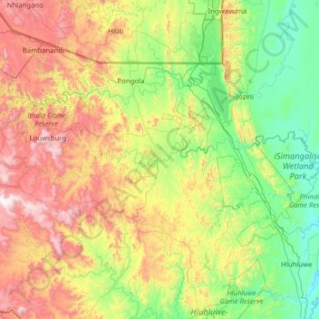
Mkuze topographic map
Interactive map
Click on the map to display elevation.
Mkuze topographic map, elevation, terrain
About this map
Name: Mkuze topographic map, elevation, terrain.
Location: Mkuze, KwaZulu-Natal, South Africa (-27.74887 31.07120 -27.55529 32.32412)
Average elevation: 472 m
Minimum elevation: 2 m
Maximum elevation: 1,554 m
Other topographic maps
Click on a map to view its topography, its elevation and its terrain.
Richards Bay
South Africa > KwaZulu-Natal > King Cetswayo District Municipality
Average elevation: 31 m
Umlazi
South Africa > KwaZulu-Natal > eThekwini Metropolitan Municipality
Umlazi is situated on a series of undulating hills at an average elevation of 101 metres above sea level between the uMlaza River to the north and the uMbokodweni River to the south. Another river running through Umlazi is the Siphingo River which also runs towards the south of the township.
Average elevation: 100 m
Ezinqoleni Local Municipality
South Africa > KwaZulu-Natal > Ugu District Municipality
Average elevation: 437 m
Jozini Local Municipality
South Africa > KwaZulu-Natal > Umkhanyakude District Municipality
Average elevation: 221 m
Manyoni Private Game Reserve
South Africa > KwaZulu-Natal > Umkhanyakude District Municipality > Jozini Local Municipality
Average elevation: 274 m
Mkuze Falls
South Africa > KwaZulu-Natal > Zululand District Municipality > uPhongolo Local Municipality
Average elevation: 347 m
Pietermaritzburg
South Africa > KwaZulu-Natal > uMgungundlovu District Municipality
Average elevation: 853 m
Kopjeskraal Dam
South Africa > KwaZulu-Natal > Sisonke District Municipality > Greater Kokstad Local Municipality
Average elevation: 1,631 m
Kosi Bay Rest Camp
South Africa > KwaZulu-Natal > Umkhanyakude District Municipality > uMhlabuyalingana Local Municipality
Average elevation: 11 m
uMngeni River
South Africa > KwaZulu-Natal > uMgungundlovu District Municipality > uMgeni Local Municipality
Average elevation: 850 m
Howick
South Africa > KwaZulu-Natal > uMgungundlovu District Municipality > uMgeni Local Municipality
Howick is possibly the location of the first crewed flight in the world. Evidence exists that a John Goodman Household flew a self made glider in 1871 and again in 1875 on the outskirts of Howick, close to Karkloof. The actual distance flown and altitude achieved differs from source to source (some sources say…
Average elevation: 1,066 m
Southbroom
South Africa > KwaZulu-Natal > Ugu District Municipality > Hibiscus Coast Local Municipality
Average elevation: 30 m
Tugela Ferry
South Africa > KwaZulu-Natal > Umzinyathi District Municipality > Msinga Local Municipality
Average elevation: 643 m
Bergview
South Africa > KwaZulu-Natal > Sisonke District Municipality > Kwa Sani Local Municipality
Average elevation: 1,578 m
Dannhauser
South Africa > KwaZulu-Natal > Amajuba District Municipality > Dannhauser Local Municipality
Average elevation: 1,339 m
Pongola
South Africa > KwaZulu-Natal > Zululand District Municipality > uPhongolo Local Municipality
Average elevation: 291 m
Umkomaas
South Africa > KwaZulu-Natal > eThekwini Metropolitan Municipality
The Umkomaas or uMkomazi River is a dominant feature of the area, being the largest river on the South Coast. The river is 298 kilometres long, from its source just south of Giant's Castle in the uKhahlamba / Drakensberg Park World Heritage Site to its mouth on the Indian Ocean. The river begins its journey at…
Average elevation: 38 m
Ntambanana Local Municipality
South Africa > KwaZulu-Natal > King Cetswayo District Municipality
Average elevation: 275 m
Ulundi
South Africa > KwaZulu-Natal > Zululand District Municipality > Ulundi Local Municipality
Average elevation: 586 m
Kidds Beach
South Africa > KwaZulu-Natal > Ugu District Municipality > Hibiscus Coast Local Municipality > Leisure Crest
Average elevation: 23 m
Dannhauser Local Municipality
South Africa > KwaZulu-Natal > Amajuba District Municipality
Average elevation: 1,299 m
Hlabisa
South Africa > KwaZulu-Natal > Umkhanyakude District Municipality > Hlabisa Local Municipality
Average elevation: 482 m
Pongolapoort Dam
South Africa > KwaZulu-Natal > Zululand District Municipality > uPhongolo Local Municipality
Average elevation: 261 m
Mhlwazini
South Africa > KwaZulu-Natal > Uthukela District Municipality > Okhahlamba Local Municipality
Average elevation: 2,935 m
Albert Falls Dam
South Africa > KwaZulu-Natal > uMgungundlovu District Municipality > uMshwathi Local Municipality > Albert Falls
Average elevation: 653 m
Spioenkop Dam
South Africa > KwaZulu-Natal > Uthukela District Municipality > Okhahlamba Local Municipality
Average elevation: 1,139 m
eMadlangeni Local Municipality
South Africa > KwaZulu-Natal > Amajuba District Municipality
Average elevation: 1,420 m
Natal Bay
South Africa > KwaZulu-Natal > eThekwini Metropolitan Municipality > Durban
Average elevation: 4 m
Kranskop
South Africa > KwaZulu-Natal > Umzinyathi District Municipality > Umvoti Local Municipality
Average elevation: 1,120 m
Msunduzi
South Africa > KwaZulu-Natal > Umkhanyakude District Municipality > Mtubatuba Local Municipality
Average elevation: 41 m
Ndlovini
South Africa > KwaZulu-Natal > Sisonke District Municipality > Kwa Sani Local Municipality
Average elevation: 1,962 m
Okhahlamba Ward 14
South Africa > KwaZulu-Natal > Uthukela District Municipality > Okhahlamba Local Municipality
Average elevation: 1,534 m
Coronation Dam
South Africa > KwaZulu-Natal > Zululand District Municipality > Abaqulusi Local Municipality
Average elevation: 1,209 m
Ingwavuma
South Africa > KwaZulu-Natal > Umkhanyakude District Municipality > Jozini Local Municipality
Average elevation: 500 m
Pinetown
South Africa > KwaZulu-Natal > eThekwini Metropolitan Municipality
Topographically, Pinetown is generally hilly with the exception of the central business district which is relatively flatter by comparison to the surrounding suburban areas. The notable high-lying areas in the eastern parts of Pinetown include Cowies Hill and the New Germany Nature Reserve reaching…
Average elevation: 296 m
Waterval Boven
South Africa > KwaZulu-Natal > Zululand District Municipality > uPhongolo Local Municipality
Average elevation: 986 m
Umbilo River
South Africa > KwaZulu-Natal > eThekwini Metropolitan Municipality > Durban
Average elevation: 69 m
Hambrook
South Africa > KwaZulu-Natal > Uthukela District Municipality > Okhahlamba Local Municipality
Average elevation: 1,128 m
Umbilo River
South Africa > KwaZulu-Natal > eThekwini Metropolitan Municipality
Average elevation: 372 m
eThekwini Ward 25
South Africa > KwaZulu-Natal > eThekwini Metropolitan Municipality
Average elevation: 72 m
Umfolozi River
South Africa > KwaZulu-Natal > King Cetswayo District Municipality
Average elevation: 75 m
Molweni River
South Africa > KwaZulu-Natal > eThekwini Metropolitan Municipality
Average elevation: 603 m
Mtubatuba
South Africa > KwaZulu-Natal > Umkhanyakude District Municipality > Mtubatuba Local Municipality
Average elevation: 64 m