
Make a donation
Tugela River topographic map
Click on the map to display elevation.
Make a donation
About this map
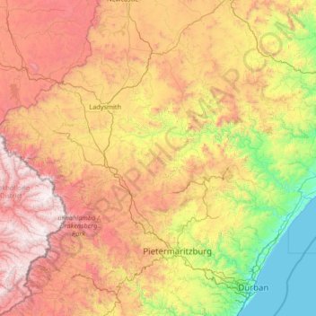
Name: Tugela River topographic map, elevation, terrain.
Location: Tugela River, KwaZulu-Natal, 4490, South Africa (-29.22422 28.87589 -28.63395 31.50057)
Average elevation: 1,181 m
Minimum elevation: -1 m
Maximum elevation: 3,438 m
Make a donation
Other topographic maps
Click on a map to view its topography, its elevation and its terrain.
Umgeni River
South Africa > KwaZulu-Natal > eThekwini Metropolitan Municipality
Average elevation: 342 m
Ezakheni
South Africa > KwaZulu-Natal > Uthukela District Municipality > Emnambithi/Ladysmith Local Municipality
Average elevation: 995 m
Wilgerfontein River
South Africa > KwaZulu-Natal > uMgungundlovu District Municipality > Msunduzi Local Municipality > Edendale
Average elevation: 781 m
Bergville
South Africa > KwaZulu-Natal > Uthukela District Municipality > Okhahlamba Local Municipality
Average elevation: 1,132 m
Make a donation
Mhlatuzana River
South Africa > KwaZulu-Natal > eThekwini Metropolitan Municipality > Chatsworth
Average elevation: 136 m
Edendale
South Africa > KwaZulu-Natal > uMgungundlovu District Municipality > Msunduzi Local Municipality > Edendale
Average elevation: 809 m
Margate Beach
South Africa > KwaZulu-Natal > Ugu District Municipality > Hibiscus Coast Local Municipality > Margate
Average elevation: 31 m
Make a donation
Sterkhorn
South Africa > KwaZulu-Natal > Uthukela District Municipality > Okhahlamba Local Municipality
Average elevation: 2,455 m
Gudlintaba
South Africa > KwaZulu-Natal > Sisonke District Municipality > Umzimkhulu Local Municipality
Average elevation: 1,204 m
Hambrook
South Africa > KwaZulu-Natal > Uthukela District Municipality > Okhahlamba Local Municipality
Average elevation: 1,128 m
Make a donation
Ndlovini
South Africa > KwaZulu-Natal > Sisonke District Municipality > Kwa Sani Local Municipality
Average elevation: 1,962 m
Kidds Beach
South Africa > KwaZulu-Natal > Ugu District Municipality > Hibiscus Coast Local Municipality > Leisure Crest
Average elevation: 23 m
Tugela Ferry
South Africa > KwaZulu-Natal > Umzinyathi District Municipality > Msinga Local Municipality
Average elevation: 643 m
uMngeni River
South Africa > KwaZulu-Natal > uMgungundlovu District Municipality > uMgeni Local Municipality
Average elevation: 850 m
Make a donation
Leisure Bay
South Africa > KwaZulu-Natal > Ugu District Municipality > Hibiscus Coast Local Municipality
Average elevation: 48 m
Greytown
South Africa > KwaZulu-Natal > Umzinyathi District Municipality > Umvoti Local Municipality
Average elevation: 1,125 m
Bulwer Park
South Africa > KwaZulu-Natal > eThekwini Metropolitan Municipality > Durban
Average elevation: 59 m
Make a donation
Palmiet River
South Africa > KwaZulu-Natal > eThekwini Metropolitan Municipality > Durban
Average elevation: 72 m
uMhlangane River
South Africa > KwaZulu-Natal > eThekwini Metropolitan Municipality > KwaMashu
Average elevation: 65 m
Elandskop
South Africa > KwaZulu-Natal > Sisonke District Municipality > Ingwe Local Municipality
Average elevation: 1,398 m
Umbilo River
South Africa > KwaZulu-Natal > eThekwini Metropolitan Municipality > Durban
Average elevation: 69 m
Make a donation
Umzimkulu River
South Africa > KwaZulu-Natal > Sisonke District Municipality > Kwa Sani Local Municipality
Average elevation: 1,438 m
Isandlwana
South Africa > KwaZulu-Natal > Umzinyathi District Municipality > Nquthu Local Municipality
Average elevation: 1,189 m
Mahlongwana River
South Africa > KwaZulu-Natal > eThekwini Metropolitan Municipality > Umkomaas
Average elevation: 85 m
Msinga
South Africa > KwaZulu-Natal > Umzinyathi District Municipality > Msinga Local Municipality
Average elevation: 1,372 m
Make a donation
Umgeni River
South Africa > KwaZulu-Natal > eThekwini Metropolitan Municipality > Queensburgh
Average elevation: 155 m
Palmiet River
South Africa > KwaZulu-Natal > eThekwini Metropolitan Municipality > Pinetown
Average elevation: 333 m
Klein Boesmans
South Africa > KwaZulu-Natal > Uthukela District Municipality > Imbabazane Local Municipality
Average elevation: 1,459 m
Umtamvuna Nature Reserve
South Africa > KwaZulu-Natal > Ugu District Municipality > Hibiscus Coast Local Municipality
Average elevation: 248 m
Make a donation
uMngeni
South Africa > KwaZulu-Natal > uMgungundlovu District Municipality > Impendle Local Municipality
Average elevation: 1,859 m
Mzimvubu
South Africa > KwaZulu-Natal > Sisonke District Municipality > Greater Kokstad Local Municipality
Average elevation: 1,671 m
Nkutu River
South Africa > KwaZulu-Natal > eThekwini Metropolitan Municipality > Forest Hills
Average elevation: 448 m
Chakaskraal
South Africa > KwaZulu-Natal > iLembe District Municipality > KwaDukuza Local Municipality
Average elevation: 68 m
Make a donation
Gingindlovu
South Africa > KwaZulu-Natal > King Cetswayo District Municipality > uMlalazi Local Municipality
Average elevation: 66 m
Winterton
South Africa > KwaZulu-Natal > Uthukela District Municipality > Okhahlamba Local Municipality
Average elevation: 1,032 m
Kamberg
South Africa > KwaZulu-Natal > uMgungundlovu District Municipality > uMgeni Local Municipality
Average elevation: 1,768 m
Chelmsford Dam
South Africa > KwaZulu-Natal > Amajuba District Municipality > Newcastle Local Municipality
Average elevation: 1,248 m
Make a donation
Wagendrift Dam
South Africa > KwaZulu-Natal > Uthukela District Municipality > Umtshezi Local Municipality
Average elevation: 1,228 m
Makhosini
South Africa > KwaZulu-Natal > Zululand District Municipality > Ulundi Local Municipality
Average elevation: 650 m
Lotheni
South Africa > KwaZulu-Natal > uMgungundlovu District Municipality > Impendle Local Municipality
Average elevation: 1,593 m
Loskop
South Africa > KwaZulu-Natal > Uthukela District Municipality > Imbabazane Local Municipality
Average elevation: 1,182 m
Make a donation
Ivy Beach
South Africa > KwaZulu-Natal > Ugu District Municipality > Hibiscus Coast Local Municipality > Leisure Bay
Average elevation: 31 m
Black Rock
South Africa > KwaZulu-Natal > Ugu District Municipality > Hibiscus Coast Local Municipality > Port Edward
Average elevation: 20 m
Mooi River
South Africa > KwaZulu-Natal > uMgungundlovu District Municipality > Mpofana Local Municipality
Average elevation: 2,012 m
Umbilo River
South Africa > KwaZulu-Natal > eThekwini Metropolitan Municipality
Average elevation: 372 m
Make a donation
Cathkin Peak
South Africa > KwaZulu-Natal > Uthukela District Municipality > Okhahlamba Local Municipality
Average elevation: 2,660 m
Molweni River
South Africa > KwaZulu-Natal > eThekwini Metropolitan Municipality
Average elevation: 603 m
Umgeni River
South Africa > KwaZulu-Natal > eThekwini Metropolitan Municipality > Queensburgh
Average elevation: 149 m
Rockfall Cave
South Africa > KwaZulu-Natal > uMgungundlovu District Municipality > Mpofana Local Municipality > Kamberg
Average elevation: 2,057 m
Make a donation
Blue Lagoon
South Africa > KwaZulu-Natal > eThekwini Metropolitan Municipality > Durban
Average elevation: 16 m
Umzimkulu
South Africa > KwaZulu-Natal > Sisonke District Municipality > Kwa Sani Local Municipality
Average elevation: 1,491 m
Mpangeni
South Africa > KwaZulu-Natal > King Cetswayo District Municipality > uMhlathuze Local Municipality
Average elevation: 66 m
Ingwavuma
South Africa > KwaZulu-Natal > Umkhanyakude District Municipality > Jozini Local Municipality
Average elevation: 500 m
Make a donation
Waterval Boven
South Africa > KwaZulu-Natal > Zululand District Municipality > uPhongolo Local Municipality
Average elevation: 986 m
Coronation Dam
South Africa > KwaZulu-Natal > Zululand District Municipality > Abaqulusi Local Municipality
Average elevation: 1,209 m
Kranskop
South Africa > KwaZulu-Natal > Umzinyathi District Municipality > Umvoti Local Municipality
Average elevation: 1,120 m
Natal Bay
South Africa > KwaZulu-Natal > eThekwini Metropolitan Municipality > Durban
Average elevation: 4 m
Make a donation
Albert Falls Dam
South Africa > KwaZulu-Natal > uMgungundlovu District Municipality > uMshwathi Local Municipality > Albert Falls
Average elevation: 653 m
Mhlwazini
South Africa > KwaZulu-Natal > Uthukela District Municipality > Okhahlamba Local Municipality
Average elevation: 2,935 m
Dannhauser
South Africa > KwaZulu-Natal > Amajuba District Municipality > Dannhauser Local Municipality
Average elevation: 1,339 m
Bergview
South Africa > KwaZulu-Natal > Sisonke District Municipality > Kwa Sani Local Municipality
Average elevation: 1,578 m
Make a donation
Kopjeskraal Dam
South Africa > KwaZulu-Natal > Sisonke District Municipality > Greater Kokstad Local Municipality
Average elevation: 1,631 m
Mkuze Falls
South Africa > KwaZulu-Natal > Zululand District Municipality > uPhongolo Local Municipality
Average elevation: 347 m
Compensation
South Africa > KwaZulu-Natal > iLembe District Municipality > KwaDukuza Local Municipality
Average elevation: 73 m
Kenmo Lake
South Africa > KwaZulu-Natal > Sisonke District Municipality > Kwa Sani Local Municipality
Average elevation: 1,533 m
Make a donation
Umhlali
South Africa > KwaZulu-Natal > iLembe District Municipality > KwaDukuza Local Municipality
Average elevation: 55 m
Amber Valley
South Africa > KwaZulu-Natal > uMgungundlovu District Municipality > uMgeni Local Municipality > Howick > Amber Valley
Average elevation: 1,039 m
Mnweni
South Africa > KwaZulu-Natal > Uthukela District Municipality > Okhahlamba Local Municipality
Average elevation: 1,604 m
Make a donation
Rocky Bay
South Africa > KwaZulu-Natal > Amajuba District Municipality > Newcastle Local Municipality
Average elevation: 1,258 m
uMngwenya
South Africa > KwaZulu-Natal > King Cetswayo District Municipality > uMlalazi Local Municipality
Average elevation: 438 m
Slangdraai Dam
South Africa > KwaZulu-Natal > Uthukela District Municipality > Emnambithi/Ladysmith Local Municipality
Average elevation: 1,322 m
Make a donation
Thompson's Beach
South Africa > KwaZulu-Natal > iLembe District Municipality > KwaDukuza Local Municipality > Shaka's Rock
Average elevation: 28 m
Portobello
South Africa > KwaZulu-Natal > Ugu District Municipality > Hibiscus Coast Local Municipality > Portobello
Average elevation: 37 m
Glenmore Beach
South Africa > KwaZulu-Natal > Ugu District Municipality > Hibiscus Coast Local Municipality > Glenmore Beach
Average elevation: 38 m
uMngeni
South Africa > KwaZulu-Natal > uMgungundlovu District Municipality > uMgeni Local Municipality
Average elevation: 1,083 m
Make a donation
Spitskop
South Africa > KwaZulu-Natal > uMgungundlovu District Municipality > Mkhambathini Local Municipality
Average elevation: 541 m
Twilight Drive Public Park
South Africa > KwaZulu-Natal > eThekwini Metropolitan Municipality > Umhlanga
Average elevation: 116 m
eNdumeni
South Africa > KwaZulu-Natal > Uthukela District Municipality > Okhahlamba Local Municipality
Average elevation: 1,652 m
Shaka's Rock
South Africa > KwaZulu-Natal > iLembe District Municipality > KwaDukuza Local Municipality > Shaka's Rock
Average elevation: 24 m
Make a donation
Highmoor
South Africa > KwaZulu-Natal > uMgungundlovu District Municipality > Mpofana Local Municipality
Average elevation: 2,009 m
Bushmans River
South Africa > KwaZulu-Natal > Uthukela District Municipality > Imbabazane Local Municipality
Average elevation: 1,291 m
Klein Boesmans
South Africa > KwaZulu-Natal > Uthukela District Municipality > Umtshezi Local Municipality > Estcourt
Average elevation: 1,177 m
Nkangala
South Africa > KwaZulu-Natal > Umkhanyakude District Municipality > Jozini Local Municipality
Average elevation: 463 m
Make a donation