
Make a donation
Katanga topographic map
Click on the map to display elevation.
Make a donation
About this map
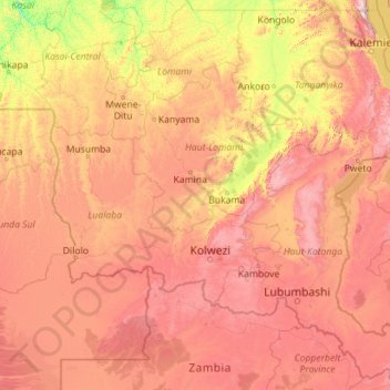
Name: Katanga topographic map, elevation, terrain.
Location: Katanga, Democratic Republic of the Congo (-13.45904 21.75076 -4.99994 30.79625)
Average elevation: 1,008 m
Minimum elevation: 386 m
Maximum elevation: 2,546 m
Make a donation
Other topographic maps
Click on a map to view its topography, its elevation and its terrain.
Kisangani
Democratic Republic of the Congo > Tshopo
The city is bordered by Banalia Territory to the north, Ubundu and Opala territories to the south, Isangi to the west, and Bafwasende municipalities to the east. Kisangani lies 324 km from Buta, 572 kilometres (355 mi) from Isiro, 696 kilometres (432 mi) from Bunia and 2,912 kilometres (1,809 mi) from…
Average elevation: 415 m
Make a donation
Make a donation
Make a donation
Kasaï-Oriental
Democratic Republic of the Congo > Kasai-Oriental > Ville de Mbujimayi
Average elevation: 621 m
Make a donation
Make a donation