
Albert Falls Dam topographic map
Interactive map
Click on the map to display elevation.
About this map
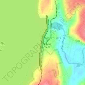
Name: Albert Falls Dam topographic map, elevation, terrain.
Average elevation: 653 m
Minimum elevation: 617 m
Maximum elevation: 693 m
Other topographic maps
Click on a map to view its topography, its elevation and its terrain.
Richards Bay
South Africa > KwaZulu-Natal > King Cetswayo District Municipality
Average elevation: 31 m
Umhlali
South Africa > KwaZulu-Natal > iLembe District Municipality > KwaDukuza Local Municipality
Average elevation: 55 m
Ezakheni
South Africa > KwaZulu-Natal > Uthukela District Municipality > Emnambithi/Ladysmith Local Municipality
Average elevation: 995 m
Izingolweni
South Africa > KwaZulu-Natal > Ugu District Municipality > Ezinqoleni Local Municipality
Average elevation: 552 m
Kenmo Lake
South Africa > KwaZulu-Natal > Sisonke District Municipality > Kwa Sani Local Municipality
Average elevation: 1,533 m
Leisure Bay
South Africa > KwaZulu-Natal > Ugu District Municipality > Hibiscus Coast Local Municipality
Average elevation: 48 m
Compensation
South Africa > KwaZulu-Natal > iLembe District Municipality > KwaDukuza Local Municipality
Average elevation: 73 m
Mtunzini
South Africa > KwaZulu-Natal > King Cetswayo District Municipality > uMlalazi Local Municipality
Average elevation: 30 m
Majuba
South Africa > KwaZulu-Natal > Amajuba District Municipality > Newcastle Local Municipality
Average elevation: 1,800 m
Pongola
South Africa > KwaZulu-Natal > Zululand District Municipality > uPhongolo Local Municipality
Average elevation: 291 m
Umkomaas
South Africa > KwaZulu-Natal > eThekwini Metropolitan Municipality
The Umkomaas or uMkomazi River is a dominant feature of the area, being the largest river on the South Coast. The river is 298 kilometres long, from its source just south of Giant's Castle in the uKhahlamba / Drakensberg Park World Heritage Site to its mouth on the Indian Ocean. The river begins its journey at…
Average elevation: 38 m
Southbroom
South Africa > KwaZulu-Natal > Ugu District Municipality > Hibiscus Coast Local Municipality
Average elevation: 30 m
Kosi Bay Rest Camp
South Africa > KwaZulu-Natal > Umkhanyakude District Municipality > uMhlabuyalingana Local Municipality
Average elevation: 11 m
Mkuze Falls
South Africa > KwaZulu-Natal > Zululand District Municipality > uPhongolo Local Municipality
Average elevation: 347 m
Kopjeskraal Dam
South Africa > KwaZulu-Natal > Sisonke District Municipality > Greater Kokstad Local Municipality
Average elevation: 1,631 m
uMngeni River
South Africa > KwaZulu-Natal > uMgungundlovu District Municipality > uMgeni Local Municipality
Average elevation: 850 m
Tugela Ferry
South Africa > KwaZulu-Natal > Umzinyathi District Municipality > Msinga Local Municipality
Average elevation: 643 m
Dannhauser
South Africa > KwaZulu-Natal > Amajuba District Municipality > Dannhauser Local Municipality
Average elevation: 1,339 m
Hlabisa
South Africa > KwaZulu-Natal > Umkhanyakude District Municipality > Hlabisa Local Municipality
Average elevation: 482 m
Bergview
South Africa > KwaZulu-Natal > Sisonke District Municipality > Kwa Sani Local Municipality
Average elevation: 1,578 m
Ulundi
South Africa > KwaZulu-Natal > Zululand District Municipality > Ulundi Local Municipality
Average elevation: 586 m
Kidds Beach
South Africa > KwaZulu-Natal > Ugu District Municipality > Hibiscus Coast Local Municipality > Leisure Crest
Average elevation: 23 m
Albert Falls Dam
South Africa > KwaZulu-Natal > uMgungundlovu District Municipality > uMshwathi Local Municipality > Albert Falls
Average elevation: 653 m
Mhlwazini
South Africa > KwaZulu-Natal > Uthukela District Municipality > Okhahlamba Local Municipality
Average elevation: 2,935 m
Ballito
South Africa > KwaZulu-Natal > iLembe District Municipality > KwaDukuza Local Municipality
Average elevation: 31 m
Waterval Boven
South Africa > KwaZulu-Natal > Zululand District Municipality > uPhongolo Local Municipality
Average elevation: 986 m
Umbilo River
South Africa > KwaZulu-Natal > eThekwini Metropolitan Municipality > Durban
Average elevation: 69 m
Natal Bay
South Africa > KwaZulu-Natal > eThekwini Metropolitan Municipality > Durban
Average elevation: 4 m
Umbilo River
South Africa > KwaZulu-Natal > eThekwini Metropolitan Municipality
Average elevation: 372 m
Kranskop
South Africa > KwaZulu-Natal > Umzinyathi District Municipality > Umvoti Local Municipality
Average elevation: 1,120 m
Coronation Dam
South Africa > KwaZulu-Natal > Zululand District Municipality > Abaqulusi Local Municipality
Average elevation: 1,209 m
Ndlovini
South Africa > KwaZulu-Natal > Sisonke District Municipality > Kwa Sani Local Municipality
Average elevation: 1,962 m
Ingwavuma
South Africa > KwaZulu-Natal > Umkhanyakude District Municipality > Jozini Local Municipality
Average elevation: 500 m
Winterton
South Africa > KwaZulu-Natal > Uthukela District Municipality > Okhahlamba Local Municipality
Average elevation: 1,032 m
Hambrook
South Africa > KwaZulu-Natal > Uthukela District Municipality > Okhahlamba Local Municipality
Average elevation: 1,128 m
Molweni River
South Africa > KwaZulu-Natal > eThekwini Metropolitan Municipality
Average elevation: 603 m
Umzimkulu
South Africa > KwaZulu-Natal > Sisonke District Municipality > Kwa Sani Local Municipality
Average elevation: 1,491 m
Gudlintaba
South Africa > KwaZulu-Natal > Sisonke District Municipality > Umzimkhulu Local Municipality
Average elevation: 1,204 m
Rockfall Cave
South Africa > KwaZulu-Natal > uMgungundlovu District Municipality > Mpofana Local Municipality > Kamberg
Average elevation: 2,057 m
Blue Lagoon
South Africa > KwaZulu-Natal > eThekwini Metropolitan Municipality > Durban
Average elevation: 16 m
Umgeni River
South Africa > KwaZulu-Natal > eThekwini Metropolitan Municipality > Queensburgh
Average elevation: 149 m
Shelly Beach
South Africa > KwaZulu-Natal > Ugu District Municipality > Hibiscus Coast Local Municipality
Average elevation: 25 m
Mpangeni
South Africa > KwaZulu-Natal > King Cetswayo District Municipality > uMhlathuze Local Municipality
Average elevation: 66 m
Mpumalanga
South Africa > KwaZulu-Natal > eThekwini Metropolitan Municipality
Average elevation: 582 m
Mooi River
South Africa > KwaZulu-Natal > uMgungundlovu District Municipality > Mpofana Local Municipality
Average elevation: 2,012 m
Cathkin Peak
South Africa > KwaZulu-Natal > Uthukela District Municipality > Okhahlamba Local Municipality
Average elevation: 2,660 m
Lotheni
South Africa > KwaZulu-Natal > uMgungundlovu District Municipality > Impendle Local Municipality
Average elevation: 1,593 m
Ivy Beach
South Africa > KwaZulu-Natal > Ugu District Municipality > Hibiscus Coast Local Municipality > Leisure Bay
Average elevation: 31 m
Black Rock
South Africa > KwaZulu-Natal > Ugu District Municipality > Hibiscus Coast Local Municipality > Port Edward
Average elevation: 20 m
Sterkhorn
South Africa > KwaZulu-Natal > Uthukela District Municipality > Okhahlamba Local Municipality
Average elevation: 2,455 m
Isandlwana
South Africa > KwaZulu-Natal > Umzinyathi District Municipality > Nquthu Local Municipality
Average elevation: 1,190 m
Loskop
South Africa > KwaZulu-Natal > Uthukela District Municipality > Imbabazane Local Municipality
Average elevation: 1,182 m
Chelmsford Dam
South Africa > KwaZulu-Natal > Amajuba District Municipality > Newcastle Local Municipality
Average elevation: 1,248 m
Wagendrift Dam
South Africa > KwaZulu-Natal > Uthukela District Municipality > Umtshezi Local Municipality
Average elevation: 1,228 m
Makhosini
South Africa > KwaZulu-Natal > Zululand District Municipality > Ulundi Local Municipality
Average elevation: 650 m
Chakaskraal
South Africa > KwaZulu-Natal > iLembe District Municipality > KwaDukuza Local Municipality
Average elevation: 68 m
Margate Beach
South Africa > KwaZulu-Natal > Ugu District Municipality > Hibiscus Coast Local Municipality > Margate
Average elevation: 31 m
Port Shepstone
South Africa > KwaZulu-Natal > Ugu District Municipality > Hibiscus Coast Local Municipality
Port Shepstone's topography is characterised by a rugged/hilly terrain with the Central Business District (CBD) lying on a large hill overlooking the Indian Ocean. Port Shepstone proper (excluding its extensions) is bordered by the uMzimkhulu River to the north and the N2 freeway to the east and is also…
Average elevation: 33 m
Mpungamhlophe
South Africa > KwaZulu-Natal > Zululand District Municipality > Ulundi Local Municipality
Average elevation: 735 m
Umdloti / eMdloti
South Africa > KwaZulu-Natal > eThekwini Metropolitan Municipality
eMdloti has a permanent population of around 3,000 people but can increase by as much as tenfold during the Christmas and Easter holiday season. Due to eMdloti's single access road (M27) from the M4/N2 interchanges, the topography, the fact that North and South Beach Roads are both cul-de-sacs and limited…
Average elevation: 38 m
Molweni River
South Africa > KwaZulu-Natal > eThekwini Metropolitan Municipality > Forest Hills
Average elevation: 227 m
Kamberg
South Africa > KwaZulu-Natal > uMgungundlovu District Municipality > uMgeni Local Municipality
Average elevation: 1,768 m
Gingindlovu
South Africa > KwaZulu-Natal > King Cetswayo District Municipality > uMlalazi Local Municipality
Average elevation: 66 m
Durban North
South Africa > KwaZulu-Natal > eThekwini Metropolitan Municipality
Average elevation: 41 m
eMondlo
South Africa > KwaZulu-Natal > Zululand District Municipality > Abaqulusi Local Municipality
Average elevation: 1,152 m
Eshowe
South Africa > KwaZulu-Natal > King Cetswayo District Municipality > uMlalazi Local Municipality
Average elevation: 457 m
Wilgerfontein River
South Africa > KwaZulu-Natal > uMgungundlovu District Municipality > Msunduzi Local Municipality > Edendale
Average elevation: 781 m
Stanger / KwaDukuza
South Africa > KwaZulu-Natal > iLembe District Municipality > KwaDukuza Local Municipality
Average elevation: 96 m
Port Edward
South Africa > KwaZulu-Natal > Ugu District Municipality > Hibiscus Coast Local Municipality
Average elevation: 42 m
Nkutu River
South Africa > KwaZulu-Natal > eThekwini Metropolitan Municipality > Forest Hills
Average elevation: 448 m
Nottingham Road
South Africa > KwaZulu-Natal > uMgungundlovu District Municipality > uMgeni Local Municipality
Average elevation: 1,478 m
Umgeni River
South Africa > KwaZulu-Natal > eThekwini Metropolitan Municipality > Queensburgh
Average elevation: 155 m
uMngeni
South Africa > KwaZulu-Natal > uMgungundlovu District Municipality > Impendle Local Municipality
Average elevation: 1,859 m
Mzimvubu
South Africa > KwaZulu-Natal > Sisonke District Municipality > Greater Kokstad Local Municipality
Average elevation: 1,671 m
Umtamvuna Nature Reserve
South Africa > KwaZulu-Natal > Ugu District Municipality > Hibiscus Coast Local Municipality
Average elevation: 248 m
Klein Boesmans
South Africa > KwaZulu-Natal > Uthukela District Municipality > Imbabazane Local Municipality
Average elevation: 1,459 m
Phakamisa
South Africa > KwaZulu-Natal > Zululand District Municipality > uPhongolo Local Municipality
Average elevation: 499 m
Umgeni River
South Africa > KwaZulu-Natal > eThekwini Metropolitan Municipality
Average elevation: 342 m
Palmiet River
South Africa > KwaZulu-Natal > eThekwini Metropolitan Municipality > Pinetown
Average elevation: 333 m
Weenen
South Africa > KwaZulu-Natal > Uthukela District Municipality > Umtshezi Local Municipality
Average elevation: 870 m
Sikhalasenkosi
South Africa > KwaZulu-Natal > King Cetswayo District Municipality > uMhlathuze Local Municipality
Average elevation: 32 m
Umhlanga Rocks
South Africa > KwaZulu-Natal > eThekwini Metropolitan Municipality
Average elevation: 45 m
uMhlangane River
South Africa > KwaZulu-Natal > eThekwini Metropolitan Municipality > KwaMashu
Average elevation: 65 m
Nkangala
South Africa > KwaZulu-Natal > Umkhanyakude District Municipality > Jozini Local Municipality
Average elevation: 463 m
Bushmans River
South Africa > KwaZulu-Natal > Uthukela District Municipality > Imbabazane Local Municipality
Average elevation: 1,291 m
Klein Boesmans
South Africa > KwaZulu-Natal > Uthukela District Municipality > Umtshezi Local Municipality > Estcourt
Average elevation: 1,177 m
Edendale
South Africa > KwaZulu-Natal > uMgungundlovu District Municipality > Msunduzi Local Municipality > Edendale
Average elevation: 809 m
Msinga
South Africa > KwaZulu-Natal > Umzinyathi District Municipality > Msinga Local Municipality
Average elevation: 1,372 m
Mhlatuzana River
South Africa > KwaZulu-Natal > eThekwini Metropolitan Municipality > Chatsworth
Average elevation: 136 m
Isandlwana
South Africa > KwaZulu-Natal > Umzinyathi District Municipality > Nquthu Local Municipality
Average elevation: 1,189 m
Shaka's Rock
South Africa > KwaZulu-Natal > iLembe District Municipality > KwaDukuza Local Municipality > Shaka's Rock
Average elevation: 24 m
Ixopo
South Africa > KwaZulu-Natal > Sisonke District Municipality > Ubuhlebezwe Local Municipality
Average elevation: 1,009 m
Highmoor
South Africa > KwaZulu-Natal > uMgungundlovu District Municipality > Mpofana Local Municipality
Average elevation: 2,009 m
Mpendle
South Africa > KwaZulu-Natal > uMgungundlovu District Municipality > Impendle Local Municipality
Average elevation: 1,592 m
Mahlongwana River
South Africa > KwaZulu-Natal > eThekwini Metropolitan Municipality > Umkomaas
Average elevation: 85 m
Greytown
South Africa > KwaZulu-Natal > Umzinyathi District Municipality > Umvoti Local Municipality
Average elevation: 1,125 m