
Make a donation
Brunei topographic map
Click on the map to display elevation.
Make a donation
About this map
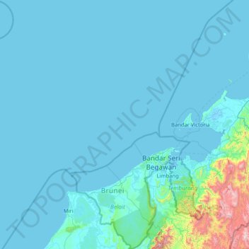
Name: Brunei topographic map, elevation, terrain.
Location: Brunei (4.00251 113.01793 6.54658 115.36356)
Average elevation: 100 m
Minimum elevation: -3 m
Maximum elevation: 2,223 m
Make a donation
Other topographic maps
Click on a map to view its topography, its elevation and its terrain.
Giyani
South Africa > Limpopo > Mopani District Municipality > Greater Giyani Local Municipality
Average elevation: 481 m
Cape Town
South Africa > Western Cape > City of Cape Town
The Cape Peninsula is 52 km long from Mouille Point in the north to Cape Point in the south, with an area of about 470 km2, and it displays more topographical variety than other similar sized areas in southern Africa, and consequently spectacular scenery. There are diverse low-nutrient soils, large rocky…
Average elevation: 53 m
Make a donation
Johannesburg
South Africa > Gauteng > City of Johannesburg Metropolitan Municipality
Johannesburg is located in the eastern plateau area of South Africa known as the Highveld, at an elevation of 1,753 metres (5,751 ft). The former Central Business District is located on the southern side of the prominent ridge called the Witwatersrand (English: White Water's Ridge) and the terrain falls to the…
Average elevation: 1,615 m
Mamelodi
South Africa > Gauteng > City of Tshwane Metropolitan Municipality
Average elevation: 1,319 m
Sebokeng
South Africa > Gauteng > Sedibeng District Municipality > Emfuleni Local Municipality
Average elevation: 1,523 m
Make a donation
Pretoria
South Africa > Gauteng > City of Tshwane Metropolitan Municipality
Pretoria is situated approximately 55 km (34 mi) north-northeast of Johannesburg in the northeast of South Africa, in a transitional belt between the plateau of the Highveld to the south and the lower-lying Bushveld to the north. It lies at an altitude of about 1,339 m (4,393 ft) above sea level, in a warm,…
Average elevation: 1,363 m
Umlazi
South Africa > KwaZulu-Natal > eThekwini Metropolitan Municipality
Umlazi is situated on a series of undulating hills at an average elevation of 101 metres above sea level between the uMlaza River to the north and the uMbokodweni River to the south. Another river running through Umlazi is the Siphingo River which also runs towards the south of the township.
Average elevation: 100 m
KuGompo City
South Africa > Eastern Cape > Buffalo City Metropolitan Municipality
Average elevation: 72 m
Make a donation
Dzanani
South Africa > Limpopo > Vhembe District Municipality > Makhado Local Municipality
Average elevation: 833 m
Midrand
South Africa > Gauteng > City of Johannesburg Metropolitan Municipality
Average elevation: 1,542 m
Make a donation
Buffalo River
South Africa > Eastern Cape > Buffalo City Metropolitan Municipality > East London
Average elevation: 120 m
iNtabazwe (Harrismith)
South Africa > Free State > Thabo Mofutsanyana District Municipality > Maluti-a-Phofung Local Municipality
Average elevation: 1,716 m
Germiston
South Africa > Gauteng > City of Ekurhuleni Metropolitan Municipality
Average elevation: 1,635 m
Thohoyandou
South Africa > Limpopo > Vhembe District Municipality > Thulamela Local Municipality
Average elevation: 632 m
Make a donation
Hertzogville
South Africa > Free State > Lejweleputswa District Municipality > Tokologo Local Municipality
Average elevation: 1,285 m
Tshepisong
South Africa > Gauteng > City of Johannesburg Metropolitan Municipality
Average elevation: 1,678 m
Make a donation
Soweto
South Africa > Gauteng > City of Johannesburg Metropolitan Municipality
Average elevation: 1,638 m
Diepsloot
South Africa > Gauteng > City of Johannesburg Metropolitan Municipality > Diepsloot
Average elevation: 1,407 m
Make a donation
Zandspruit
South Africa > Limpopo > Mopani District Municipality > Maruleng Local Municipality
Average elevation: 541 m
Thembisa
South Africa > Gauteng > City of Ekurhuleni Metropolitan Municipality
Average elevation: 1,594 m
Port St Johns
South Africa > Eastern Cape > O.R. Tambo District Municipality > Port St Johns Local Municipality
Average elevation: 85 m
Make a donation
Sekgakgapeng
South Africa > Limpopo > Waterberg District Municipality > Mogalakwena Local Municipality
Average elevation: 1,118 m
Drakensberg
The Drakensberg (Zulu: uKhahlamba, Sotho: Maloti, Afrikaans: Drakensberge) is the eastern portion of the Great Escarpment, which encloses the central Southern African plateau. The Great Escarpment reaches its greatest elevation – 2,000 to 3,482 metres (6,562 to 11,424 feet) within the border region of South…
Average elevation: 3,286 m
Make a donation
Mbombela (Nelspruit)
South Africa > Mpumalanga > Ehlanzeni District Municipality
Average elevation: 842 m
Gqeberha
South Africa > Eastern Cape > Nelson Mandela Bay Metropolitan Municipality
Average elevation: 37 m
Malavuwe
South Africa > Limpopo > Vhembe District Municipality > Thulamela Local Municipality
Average elevation: 522 m
Make a donation
Vaal Dam
South Africa > Free State > Fezile Dabi District Municipality > Metsimaholo Local Municipality > Deneysville
Average elevation: 1,481 m
Kimberley
South Africa > Northern Cape > Frances Baard District Municipality
Kimberley is set in a relatively flat landscape with no prominent topographic features within the urban limits. The only "hills" are debris dumps generated by more than a century of diamond mining. From the 1990s these were being recycled and poured back into De Beers Mine (by 2010 it was filled to within a…
Average elevation: 1,203 m
Rustenburg
South Africa > North West > Bojanala Platinum District Municipality
Rustenburg has a humid subtropical climate (Köppen Cwa), with a relatively high degree of diurnal temperature variation due to the high elevation. It has very warm summers (from December to February) and mild winters (from June to August). Due to the altitude, summers are not quite as hot as one might expect.…
Average elevation: 1,217 m
Bizana
South Africa > Eastern Cape > Alfred Nzo District Municipality > Mbizana Local Municipality
Average elevation: 823 m
Make a donation
Randfontein
South Africa > Gauteng > West Rand District Municipality > Randfontein Local Municipality
As of 2011, Randfontein has a population of 149,286, which incorporates Mohlakeng and Toekomsrus. (In 2001, the population was 128,731.) The average elevation of the town is 1709m above sea level. The total municipal area, after recent restructuring, is 475 km2 (183 sq mi).
Average elevation: 1,701 m
Kanyamazane
South Africa > Mpumalanga > Ehlanzeni District Municipality > Mbombela
Average elevation: 637 m
Make a donation
Ennerdale
South Africa > Gauteng > City of Johannesburg Metropolitan Municipality
Average elevation: 1,630 m
Mogalakwena
South Africa > Limpopo > Waterberg District Municipality > Mogalakwena Local Municipality
Average elevation: 855 m
Make a donation
Nahoon River
South Africa > Eastern Cape > Buffalo City Metropolitan Municipality > East London
Average elevation: 136 m
Phuthaditjhaba
South Africa > Free State > Thabo Mofutsanyana District Municipality > Maluti-a-Phofung Local Municipality
Average elevation: 1,736 m
Malamulele
South Africa > Limpopo > Vhembe District Municipality > Thulamela Local Municipality
Average elevation: 542 m
Make a donation
Canberra
The area chosen for the capital had been inhabited by Indigenous Australians for up to 21,000 years, with the principal group being the Ngunnawal people. European settlement commenced in the first half of the 19th century, as evidenced by surviving landmarks such as St John's Anglican Church and Blundells…
Average elevation: 638 m
Hillcrest
South Africa > KwaZulu-Natal > eThekwini Metropolitan Municipality
Hillcrest is situated in the Upper Highway Area of Durban, approximately 32 kilometres (20 mi) north-west of the city and is bordered by Gillitts and Everton to the east, Waterfall to the north-east and Botha's Hill and Assagay to the north-west. It lies at an altitude of approximately 680 m (2231 ft) above…
Average elevation: 625 m
Kloof
South Africa > KwaZulu-Natal > eThekwini Metropolitan Municipality
The further subdivisions and sale of portions of Richmond Farm No. 999 by the Field heirs after 1901 resulted in the birth of Kloof as a residential area: numerous plots were sold to wealthy Durban residents and businessmen, who built country house retreats close to the city, but (due to its 550 m above sea…
Average elevation: 480 m
Stanger / KwaDukuza
South Africa > KwaZulu-Natal > iLembe District Municipality > KwaDukuza Local Municipality
Average elevation: 96 m
Make a donation
Daveyton
South Africa > Gauteng > City of Ekurhuleni Metropolitan Municipality
Average elevation: 1,613 m
Sandfontein
South Africa > North West > Bojanala Platinum District Municipality > Moses Kotane Local Municipality
Average elevation: 1,149 m
Dordrecht
South Africa > Eastern Cape > Chris Hani District Municipality > Emalahleni Local Municipality
Average elevation: 1,678 m
Make a donation
Gariep Dam
South Africa > Eastern Cape > Joe Gqabi District Municipality > Gariep Local Municipality
Average elevation: 1,276 m
Lebowakgomo
South Africa > Limpopo > Capricorn District Municipality > Lepelle-Nkumpi Local Municipality
Average elevation: 1,017 m
Make a donation
Vanrhynsdorp
South Africa > Western Cape > West Coast District Municipality > Matzikama Local Municipality
Average elevation: 139 m
Hoedspruit
South Africa > Limpopo > Mopani District Municipality > Maruleng Local Municipality
Average elevation: 524 m
Pinetown
South Africa > KwaZulu-Natal > eThekwini Metropolitan Municipality
Topographically, Pinetown is generally hilly with the exception of the central business district which is relatively flatter by comparison to the surrounding suburban areas. The notable high-lying areas in the eastern parts of Pinetown include Cowies Hill and the New Germany Nature Reserve reaching…
Average elevation: 356 m
Durban North
South Africa > KwaZulu-Natal > eThekwini Metropolitan Municipality
Average elevation: 41 m
Make a donation
Magaliesburg
South Africa > Gauteng > West Rand District Municipality > Mogale City Local Municipality
Average elevation: 1,504 m
Burgersfort
South Africa > Limpopo > Sekhukhune District Municipality > Greater Tubatse Local Municipality
Average elevation: 810 m
Homestead Lake
South Africa > Gauteng > City of Ekurhuleni Metropolitan Municipality > Benoni
Average elevation: 1,649 m
Edendale
South Africa > KwaZulu-Natal > uMgungundlovu District Municipality > Msunduzi Local Municipality > Edendale
Average elevation: 809 m
Make a donation
Leeupoort Vakansiedorp
South Africa > Limpopo > Waterberg District Municipality > Thabazimbi Local Municipality
Average elevation: 1,087 m
Centurion
South Africa > Gauteng > City of Tshwane Metropolitan Municipality
Average elevation: 1,451 m
Thokoza Park
South Africa > Gauteng > City of Johannesburg Metropolitan Municipality > Soweto
Average elevation: 1,604 m
Ga-Rankuwa
South Africa > Gauteng > City of Tshwane Metropolitan Municipality
Average elevation: 1,227 m
Make a donation
Carletonville
South Africa > Gauteng > West Rand District Municipality > Merafong City Local Municipality
Average elevation: 1,539 m
Cofimvaba
South Africa > Eastern Cape > Chris Hani District Municipality > Intsika Yethu Local Municipality
Average elevation: 997 m
Etwatwa
South Africa > Gauteng > City of Ekurhuleni Metropolitan Municipality
Average elevation: 1,611 m
Mogalakwena River
South Africa > Limpopo > Waterberg District Municipality > Mogalakwena Local Municipality > Sekgakgapeng
Average elevation: 1,171 m
Make a donation
Kempton Park
South Africa > Gauteng > City of Ekurhuleni Metropolitan Municipality
Average elevation: 1,654 m
Benoni
South Africa > Gauteng > City of Ekurhuleni Metropolitan Municipality
Average elevation: 1,645 m
Hartbeespoort Dam
South Africa > North West > Bojanala Platinum District Municipality > Madibeng Local Municipality > Kosmos
Average elevation: 1,254 m
Make a donation
Springs
South Africa > Gauteng > City of Ekurhuleni Metropolitan Municipality
Average elevation: 1,606 m
George
South Africa > Western Cape > Garden Route District Municipality > George Local Municipality
Average elevation: 244 m
Alberton
South Africa > Gauteng > City of Ekurhuleni Metropolitan Municipality
Alberton lies at an elevation of approximately 1,570 m (5,150 ft) above sea level on the banks of the Natal Spruit, approximately 11 km south-east of Johannesburg CBD, 59 km south of Pretoria and 49 km north-east of Vereeniging. Organisationally and administratively, it is included in the City of Ekurhuleni…
Average elevation: 1,617 m
Bloemfontein
South Africa > Free State > Mangaung Metropolitan Municipality
Situated at an elevation of 1,395 m (4,577 ft) above sea level, the city is home to approximately 520,000 residents and forms part of the Mangaung Metropolitan Municipality which has a population of 747,431. It was one of the host cities for the 2010 FIFA World Cup.
Average elevation: 1,374 m
Make a donation
Umkomaas
South Africa > KwaZulu-Natal > eThekwini Metropolitan Municipality
The Umkomaas or uMkomazi River is a dominant feature of the area, being the largest river on the South Coast. The river is 298 kilometres long, from its source just south of Giant's Castle in the uKhahlamba / Drakensberg Park World Heritage Site to its mouth on the Indian Ocean. The river begins its journey at…
Average elevation: 38 m
Delmas
South Africa > Mpumalanga > Nkangala > Victor Khanye Local Municipality
Average elevation: 1,566 m
Potchefstroom
South Africa > North West > Dr Kenneth Kaunda District Municipality
Potchefstroom has hosted two World Cup-winning teams (in cricket and football), and is a home away from home for international athletes and teams. At 1,400 metres (4,600 ft) altitude, it provides a good balance between altitude and quality training. The city has no large factories, and good air quality.…
Average elevation: 1,393 m
Lenasia
South Africa > Gauteng > City of Johannesburg Metropolitan Municipality
Average elevation: 1,590 m
Make a donation
Thabazimbi
South Africa > Limpopo > Waterberg District Municipality > Thabazimbi Local Municipality
Average elevation: 1,077 m
Bothaville
South Africa > Free State > Lejweleputswa District Municipality > Nala Local Municipality
Average elevation: 1,287 m
Stellenbosch
South Africa > Western Cape > Cape Winelands District Municipality > Stellenbosch Local Municipality
Stellenbosch is 53 km (33 mi) east of Cape Town via National Route N1. Stellenbosch is in a hilly region of the Cape Winelands, and is sheltered in a valley at an average elevation of 136 m (446 ft), flanked on the west by Papegaaiberg (Afrikaans: Parrot Mountain), which is actually a hill. To the south is…
Average elevation: 287 m
Pietermaritzburg
South Africa > KwaZulu-Natal > uMgungundlovu District Municipality
Average elevation: 853 m
Make a donation