
Kansas topographic map
Interactive map
Click on the map to display elevation.
About this map
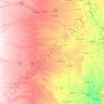
Name: Kansas topographic map, elevation, terrain.
Location: Kansas, United States (36.99307 -102.05179 40.00323 -94.58820)
Average elevation: 601 m
Minimum elevation: 150 m
Maximum elevation: 1,302 m
The western two-thirds of the state, lying in the great central plain of the United States, has a generally flat or undulating surface, while the eastern third has many hills and forests. The land gradually rises from east to west; its altitude ranges from 684 ft (208 m) along the Verdigris River at Coffeyville in Montgomery County, to 4,039 ft (1,231 m) at Mount Sunflower, 0.5 miles (0.80 kilometers) from the Colorado border, in Wallace County. It is a common misconception that Kansas is the flattest state in the nation – in 2003, a tongue-in-cheek study famously declared the state "flatter than a pancake". In fact, Kansas has a maximum topographic relief of 3,360 ft (1,020 m), making it the 23rd flattest U.S. state measured by maximum relief.
Other topographic maps
Click on a map to view its topography, its elevation and its terrain.
Blowing Rock
United States > North Carolina > Watauga County
Blowing Rock, Watauga County, North Carolina, 28605, United States
Average elevation: 1,032 m
Mitchell Plain
United States > Indiana > Washington County
Mitchell Plain, Washington County, Indiana, 47120, United States
Average elevation: 205 m
Oakland
United States > California > Alameda County
Oakland, Alameda County, California, United States
Average elevation: 51 m
Soul City
United States > North Carolina > Warren County
Soul City, Warren County, North Carolina, 27570, United States
Average elevation: 115 m
Hogsback
United States > New York > Onondaga County
Hogsback, Onondaga County, New York, 13063, United States
Average elevation: 411 m
Red Hill
United States > South Carolina > Horry County > Conway
Red Hill, Conway, Horry County, South Carolina, United States
Average elevation: 9 m
Westbrook
United States > Texas > Mitchell County
Westbrook, Mitchell County, Texas, 79565, United States
Average elevation: 657 m
Rohnert Park
United States > California > Sonoma County
Rohnert Park, Sonoma County, California, United States
Average elevation: 39 m
Yellowstone County
Yellowstone County, Montana, United States
Average elevation: 1,067 m
Sevierville
United States > Tennessee > Sevier County
Sevierville, Sevier County, East Tennessee, Tennessee, United States
Average elevation: 313 m
Siloam
United States > New Jersey > Monmouth County > Freehold Township
Siloam, Freehold Township, Monmouth County, New Jersey, United States
Average elevation: 44 m
Amherst County
Amherst County, Virginia, United States
Average elevation: 329 m
Clifton
United States > New Jersey > Passaic County
Clifton, Passaic County, New Jersey, United States
Average elevation: 56 m
Chantilly
United States > Virginia > Fairfax County
Chantilly, Fairfax County, Virginia, United States
Average elevation: 96 m
Shanty Town
United States > Minnesota > Olmsted County
Shanty Town, Olmsted County, Minnesota, United States
Average elevation: 353 m
Loch Sheldrake
United States > New York > Sullivan County
Loch Sheldrake, Town of Fallsburg, Sullivan County, New York, United States
Average elevation: 448 m
Kyles
United States > Ohio > Butler County
Kyles, Liberty Township, Butler County, Ohio, 45050, United States
Average elevation: 222 m
Barrington
United States > Rhode Island > Bristol County
Barrington, Bristol County, Rhode Island, 02806, United States
Average elevation: 4 m
Pasco
United States > Washington > Franklin County
Pasco, Franklin County, Washington, 99301, United States
Average elevation: 141 m
Parsippany-Troy Hills
United States > New Jersey > Morris County
Parsippany-Troy Hills, Morris County, New Jersey, United States
Average elevation: 113 m
Rosedale
United States > California > Kern County
Rosedale, Kern County, California, United States
Average elevation: 113 m
Black Rock
United States > Arkansas > Lawrence County
Black Rock, Lawrence County, Arkansas, 72415, United States
Average elevation: 90 m
Trussville Manor
United States > Alabama > Jefferson County > Trussville
Trussville Manor, Trussville, Jefferson County, Alabama, 35173, United States
Average elevation: 237 m
Redoubt
United States > Alaska > Anchorage
Redoubt, Anchorage, Alaska, United States
Average elevation: 49 m
Flagstaff
United States > Arizona > Coconino County
Flagstaff, Coconino County, Arizona, United States
Average elevation: 2,176 m
Campbell County
Campbell County, Kentucky, United States
Average elevation: 223 m
Village of Clayville
United States > New York > Oneida County
Village of Clayville, Town of Paris, Oneida County, New York, United States
Average elevation: 361 m
Athens-Clarke County Unified Government
United States > Georgia > Athens-Clarke County
Athens-Clarke County Unified Government, Athens-Clarke County, Georgia, United States
Average elevation: 219 m
Fife Lake
United States > Michigan > Grand Traverse County
Fife Lake, Fife Lake Township, Grand Traverse County, Michigan, United States
Average elevation: 317 m
Riverbanks
United States > South Carolina > Richland County > Columbia
Riverbanks, Columbia, Richland County, South Carolina, 29202, United States
Average elevation: 69 m
Laurel
United States > Maryland > Prince George's County
Laurel, Prince George's County, Maryland, 20707, United States
Average elevation: 62 m
Austin
United States > Texas > Travis County
Austin, Travis County, Texas, United States
Average elevation: 216 m
Charlottesville
Charlottesville, Virginia, 22902, United States
Average elevation: 173 m
Kingsport
United States > Tennessee > Sullivan County
Kingsport, Sullivan County, East Tennessee, Tennessee, United States
Average elevation: 453 m
Codell
United States > Kansas > Rooks County
Codell, Rooks County, Kansas, United States
Average elevation: 620 m
Eliot
United States > Maine > York County
Eliot, York County, Maine, 03903, United States
Average elevation: 17 m
Seattle
United States > Washington > King County
Seattle, King County, Washington, United States
Average elevation: 40 m
Cherokee County
United States > North Carolina
Cherokee County, North Carolina, United States
Average elevation: 655 m
Pittsburgh
United States > Pennsylvania > Allegheny County
Pittsburgh, Allegheny County, Pennsylvania, United States
Average elevation: 303 m
West Park
United States > Florida > Broward County > West Park
West Park, Broward County, Florida, United States
Average elevation: 8 m
Philadelphia
United States > Pennsylvania > Philadelphia County
Philadelphia, Philadelphia County, Pennsylvania, United States
Average elevation: 44 m
Berkeley
United States > California > Alameda County
Berkeley, Alameda County, California, United States
Average elevation: 109 m
Ann Arbor
United States > Michigan > Washtenaw County
Ann Arbor, Washtenaw County, Michigan, United States
Average elevation: 272 m
Savannah
United States > Georgia > Chatham County
Savannah, Chatham County, Georgia, United States
Average elevation: 4 m
Quincy
United States > Washington > Grant County
Quincy, Grant County, Washington, United States
Average elevation: 400 m