
Lesotho topographic map
Click on the map to display elevation.
Lesotho
Lesotho covers 30,355 km2 (11,720 sq mi). It is the only independent state in the world that lies entirely above 1,000 metres (3,281 ft) in elevation. Its lowest point of 1,400 metres (4,593 ft) is thus the highest lowest point of any country in the world. Over 80% of the country lies above 1,800 metres (5,906 ft). Lesotho is the southernmost landlocked country in the world. It is the largest of the world's three independent states completely surrounded by the territory of another country, with Vatican City and San Marino being the other two. It is the only such state outside the Italian peninsula, and the only one that is not a microstate.
About this map
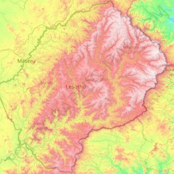
Name: Lesotho topographic map, elevation, terrain.
Location: Lesotho (-30.67804 27.01138 -28.57057 29.45571)
Average elevation: 1,958 m
Minimum elevation: 1,022 m
Maximum elevation: 3,455 m
Other topographic maps
Click on a map to view its topography, its elevation and its terrain.
Pretoria
South Africa > Gauteng > City of Tshwane Metropolitan Municipality
Pretoria is situated approximately 55 km (34 mi) north-northeast of Johannesburg in the northeast of South Africa, in a transitional belt between the plateau of the Highveld to the south and the lower-lying Bushveld to the north. It lies at an altitude of about 1,339 m (4,393 ft) above sea level, in a warm,…
Average elevation: 1,363 m
Johannesburg
South Africa > Gauteng > City of Johannesburg Metropolitan Municipality
Johannesburg is located in the eastern plateau area of South Africa known as the Highveld, at an elevation of 1,753 metres (5,751 ft). The former Central Business District is located on the southern side of the prominent ridge called the Witwatersrand (English: White Water's Ridge) and the terrain falls to the…
Average elevation: 1,615 m
Table Mountain
South Africa > Western Cape > City of Cape Town > Cape Town
Table Mountain is at the northern end of a sandstone mountain range that forms the spine of the Cape Peninsula that terminates approximately 50 kilometres (30 mi) to the south at the Cape of Good Hope and Cape Point. Immediately to the south of Table Mountain is a rugged "plateau" at a somewhat lower elevation…
Average elevation: 583 m
Cape Town
South Africa > Western Cape > City of Cape Town
The Cape Peninsula is 52 km long from Mouille Point in the north to Cape Point in the south, with an area of about 470 km2, and it displays more topographical variety than other similar sized areas in southern Africa, and consequently spectacular scenery. There are diverse low-nutrient soils, large rocky…
Average elevation: 53 m
Canberra
The area chosen for the capital had been inhabited by Indigenous Australians for up to 21,000 years, with the principal group being the Ngunnawal people. European settlement commenced in the first half of the 19th century, as evidenced by surviving landmarks such as St John's Anglican Church and Blundells…
Average elevation: 638 m
Bulwer Park
South Africa > KwaZulu-Natal > eThekwini Metropolitan Municipality > Durban
Average elevation: 59 m
Worcester
South Africa > Western Cape > Cape Winelands District Municipality > Breede Valley Local Municipality
Worcester is located at an elevation of 220 metres (720 ft) and can be reached by road either travelling on the N1 highway through the Huguenot Tunnel or by driving through spectacular mountain passes. From Cape Town Du Toitskloof, from Wellington Bainskloof, from Malmesbury, Western Cape Nieuwekloof, from…
Average elevation: 252 m
Hillcrest
South Africa > KwaZulu-Natal > eThekwini Metropolitan Municipality
Hillcrest is situated in the Upper Highway Area of Durban, approximately 32 kilometres (20 mi) north-west of the city and is bordered by Gillitts and Everton to the east, Waterfall to the north-east and Botha's Hill and Assagay to the north-west. It lies at an altitude of approximately 680 m (2231 ft) above…
Average elevation: 625 m
Kleinbaai
South Africa > Western Cape > Overberg District Municipality > Overstrand Local Municipality
Average elevation: 15 m
Sekgakgapeng
South Africa > Limpopo > Waterberg District Municipality > Mogalakwena Local Municipality
Average elevation: 1,118 m
Boknes
South Africa > Eastern Cape > Sarah Baartman District Municipality > Ndlambe Local Municipality
Average elevation: 18 m
The Three Rondavels
South Africa > Mpumalanga > Ehlanzeni District Municipality > Thaba Chweu Local Municipality
The Mogologolo (1,794 m), Mariepskop (1,944 m) and Hebronberg (1,767 m) massifs are partially included in the reserve. Elevation varies from 560 m to 1,944 m above sea level. Its resort areas are F.H. Odendaal and Swadeni, the latter only accessible from Limpopo province. The area of approximately 29,000…
Average elevation: 1,042 m
Ulundi
South Africa > KwaZulu-Natal > Zululand District Municipality > Ulundi Local Municipality
Average elevation: 586 m
Selati Game Reserve
South Africa > Limpopo > Mopani District Municipality > Ba-Phalaborwa Local Municipality
Average elevation: 533 m
Silwerkrans
South Africa > North West > Bojanala Platinum District Municipality > Moses Kotane Local Municipality
Average elevation: 1,212 m
Tshepisong
South Africa > Gauteng > City of Johannesburg Metropolitan Municipality
Average elevation: 1,678 m
Sun City
South Africa > North West > Bojanala Platinum District Municipality > Moses Kotane Local Municipality > Sun City
Average elevation: 1,158 m
Kempton Park
South Africa > Gauteng > City of Ekurhuleni Metropolitan Municipality
Average elevation: 1,654 m
Volksrust
South Africa > Mpumalanga > Gert Sibande > Pixley Ka Seme Local Municipality
The town was laid out in 1888 on the farms Boschpad Drift, Rooibult or Llanwarne, Verkyk and Zandfontein, and proclaimed in 1889. It lies at an elevation of 5,429 feet (1,655 m), and 4 miles (6.4 km) north of the pass through the Drakensberg known as Laing's Nek. Municipal status was attained in 1904.
Average elevation: 1,688 m
KuGompo City
South Africa > Eastern Cape > Buffalo City Metropolitan Municipality
Average elevation: 72 m
Magaliesberg Biosphere Reserve
The reserve includes a variety of landscapes including slopes, cliffs, crests, kloofs, rivers, wetlands and valleys. Although the area covers a diverse geological area, it consists mainly of the Magaliesberg mountain complex comprising two geological formations: the Transvaal System and the Bushveld Igneous…
Average elevation: 1,366 m
Magaliesberg Biosphere Reserve
The reserve includes a variety of landscapes including slopes, cliffs, crests, kloofs, rivers, wetlands and valleys. Although the area covers a diverse geological area, it consists mainly of the Magaliesberg mountain complex comprising two geological formations: the Transvaal System and the Bushveld Igneous…
Average elevation: 1,370 m
Mamelodi
South Africa > Gauteng > City of Tshwane Metropolitan Municipality
Average elevation: 1,319 m
Bloemhof Dam
South Africa > Eastern Cape > Sarah Baartman District Municipality > Camdeboo Local Municipality
Average elevation: 1,152 m
Vaal Dam
South Africa > Free State > Fezile Dabi District Municipality > Metsimaholo Local Municipality > Deneysville
Average elevation: 1,481 m
Bethlehem
South Africa > Free State > Thabo Mofutsanyana District Municipality > Dihlabeng Local Municipality
The city lies at an altitude of 1,700 metres (5,600 ft) and this contributes to its cool climate with frosty winters and mild summers. The average annual temperature is around 14 °C (57 °F).
Average elevation: 1,675 m
Randburg
South Africa > Gauteng > City of Johannesburg Metropolitan Municipality
Average elevation: 1,567 m
White River
South Africa > Mpumalanga > Ehlanzeni District Municipality > Mbombela
White River is located in the low altitude subtropical Lowveld climatic zone. Savannah and woodland scattered with granite outcrops form the indigenous habitat. Compared to other parts of South Africa, the climate is mild with good rainfall. Nevertheless, like the rest of South Africa, White River and its…
Average elevation: 902 m
Stellenbosch
South Africa > Western Cape > Cape Winelands District Municipality > Stellenbosch Local Municipality
Stellenbosch is 53 km (33 mi) east of Cape Town via National Route N1. Stellenbosch is in a hilly region of the Cape Winelands, and is sheltered in a valley at an average elevation of 136 m (446 ft), flanked on the west by Papegaaiberg (Afrikaans: Parrot Mountain), which is actually a hill. To the south is…
Average elevation: 287 m
Gqeberha
South Africa > Eastern Cape > Nelson Mandela Bay Metropolitan Municipality
Average elevation: 37 m
Paarl Mountain Nature Reserve
South Africa > Western Cape > Cape Winelands District Municipality > Paarl
Average elevation: 395 m
Phokeng
South Africa > North West > Bojanala Platinum District Municipality > Rustenburg Local Municipality
Average elevation: 1,202 m
Ga-Masemola
South Africa > Limpopo > Sekhukhune District Municipality > Makhuduthamaga Local Municipality
Average elevation: 911 m
Soutpansberg
South Africa > Northern Cape > Namakwa District Municipality > Hantam Local Municipality
Average elevation: 1,170 m
Rapitsi
South Africa > Limpopo > Capricorn District Municipality > Aganang Local Municipality
Average elevation: 1,141 m
Pienaarsrivier
South Africa > Limpopo > Waterberg District Municipality > Bela Bela Local Municipality
Average elevation: 1,042 m
Fauresmith
South Africa > Free State > Xhariep District Municipality > Kopanong Local Municipality
Average elevation: 1,411 m
Nazareth
South Africa > Mpumalanga > Gert Sibande > Albert Luthuli Local Municipality
Average elevation: 1,471 m
Moorreesburg
South Africa > Western Cape > West Coast District Municipality > Swartland Local Municipality
Average elevation: 172 m
Ga-Rankuwa
South Africa > Gauteng > City of Tshwane Metropolitan Municipality
Average elevation: 1,227 m
Douglas
South Africa > Northern Cape > Pixley ka Seme District Municipality > Siyancuma Local Municipality
Douglas has a record of its elevation above sea level of 1030.22 meters (3379.99 feet). Comparing Douglas district's yearly temperature to South Africa's averages, the records show that it is 4.01% higher with a temperature 25.23 °C (77.41 °F). Douglas is known for its Subtropical desert climate with 38.78…
Average elevation: 1,010 m
Smithfield
South Africa > Free State > Xhariep District Municipality > Mohokare Local Municipality
Average elevation: 1,441 m
Tesselaarsdal
South Africa > Western Cape > Theewaterskloof Local Municipality
Average elevation: 273 m
Bloemhof Dam
South Africa > Free State > Lejweleputswa District Municipality > Tswelopele Local Municipality
Average elevation: 1,228 m
Madadeni
South Africa > KwaZulu-Natal > Amajuba District Municipality > Newcastle Local Municipality
Average elevation: 1,196 m
Carolina
South Africa > Mpumalanga > Gert Sibande > Albert Luthuli Local Municipality
Average elevation: 1,675 m
Randburg
South Africa > Gauteng > City of Johannesburg Metropolitan Municipality
Average elevation: 1,567 m
Carletonville
South Africa > Gauteng > West Rand District Municipality > Merafong City Local Municipality
Average elevation: 1,539 m
Strandfontein
South Africa > Western Cape > West Coast District Municipality > Matzikama Local Municipality
Average elevation: 36 m
Madibogo
South Africa > North West > Ngaka Modiri Molema District Municipality > Ratlou Local Municipality
Average elevation: 1,292 m
Onrus River
South Africa > Western Cape > Overberg District Municipality > Overstrand Local Municipality
Average elevation: 232 m
Jansenville
South Africa > Eastern Cape > Sarah Baartman District Municipality > Ikwezi Local Municipality
Average elevation: 448 m
Motherwell
South Africa > Eastern Cape > Nelson Mandela Bay Metropolitan Municipality
Average elevation: 67 m
Hlohlolwane (Clocolan)
South Africa > Free State > Thabo Mofutsanyana District Municipality > Setsoto Local Municipality
Average elevation: 1,593 m
Verneukpan
South Africa > Northern Cape > Namakwa District Municipality > Hantam Local Municipality
Average elevation: 879 m
Bulwer
South Africa > KwaZulu-Natal > Sisonke District Municipality > Ingwe Local Municipality
Average elevation: 1,534 m
Thembisa
South Africa > Gauteng > City of Ekurhuleni Metropolitan Municipality
Average elevation: 1,594 m
Barrydale
South Africa > Western Cape > Overberg District Municipality > Swellendam Local Municipality
Average elevation: 425 m
Vanderkloof
South Africa > Northern Cape > Pixley ka Seme District Municipality > Renosterberg Local Municipality
Average elevation: 1,219 m
Kayser's Beach
South Africa > Eastern Cape > Buffalo City Metropolitan Municipality
Average elevation: 28 m
Marble Hall
South Africa > Limpopo > Sekhukhune District Municipality > Ephraim Mogale Local Municipality
Average elevation: 892 m
Marikana
South Africa > North West > Bojanala Platinum District Municipality > Rustenburg Local Municipality
Average elevation: 1,148 m
Henley Dam
South Africa > KwaZulu-Natal > uMgungundlovu District Municipality > Msunduzi Local Municipality
Average elevation: 976 m
Umhlanga Rocks
South Africa > KwaZulu-Natal > eThekwini Metropolitan Municipality
Average elevation: 45 m
Nkandla
South Africa > KwaZulu-Natal > King Cetswayo District Municipality > Nkandla Local Municipality
Average elevation: 1,040 m
Pigeon Valley
South Africa > KwaZulu-Natal > eThekwini Metropolitan Municipality > Durban
Average elevation: 69 m
Loskop Dam
South Africa > Mpumalanga > Nkangala > Steve Tshwete Local Municipality
Average elevation: 1,211 m
Sandton
South Africa > Gauteng > City of Johannesburg Metropolitan Municipality
Average elevation: 1,583 m
Mzimvubu
South Africa > Eastern Cape > Alfred Nzo District Municipality > Umzimvubu Local Municipality
Average elevation: 1,041 m
Meyerton
South Africa > Gauteng > Sedibeng District Municipality > Midvaal Local Municipality
Average elevation: 1,479 m
Hex River
South Africa > Western Cape > Cape Winelands District Municipality > Breede Valley Local Municipality
Average elevation: 644 m
Vanderkloof Dam
South Africa > Free State > Xhariep District Municipality > Letsemeng Local Municipality
Average elevation: 1,188 m
Kuruman
South Africa > Northern Cape > John Taolo Gaetsewe District Municipality > Ga-Segonyana Local Municipality
Average elevation: 1,144 m
Viljoenskroon
South Africa > Free State > Fezile Dabi District Municipality > Moqhaka Local Municipality
Average elevation: 1,335 m
Brakpan
South Africa > Gauteng > City of Ekurhuleni Metropolitan Municipality
Average elevation: 1,624 m
Middelburg
South Africa > Mpumalanga > Nkangala > Steve Tshwete Local Municipality
Average elevation: 1,493 m