Geolocate

Berea District topographic map

Interactive map

Click on the map to display elevation.

Berea District

In the west, Berea borders on the Free State Province of South Africa. Domestically, it borders on the following districts: Leribe District in the north, Thaba-Tseka District in southeast and Maseru District in the south. The Western districts of Lesotho has predominantly low land zone with an elevation of 1,500 m (4,900 ft) 1,800 m (5,900 ft) above the sea level. These lands are the major agricultural zones in the country. The average annual rainfall in the country is 100 cm (39 in), most of which is received during the rainy season of October to April. Though it rains during all the months of the year, groundwater is limited on account of run-offs. The region has a temperate climate on account of the elevation and is humid during most parts of the year. The temperature in low lands vary from 32 °C (90 °F) to −7 °C (19 °F) in the winter.

Wikipedia (CC-BY-SA 3.0)

About this map

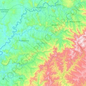
Name: Berea District topographic map, elevation, terrain.

Location: Berea District, 200, Lesotho (-29.39636 27.50987 -28.94598 28.29361)

Average elevation: 1,899 m

Minimum elevation: 1,490 m

Maximum elevation: 3,109 m

Other topographic maps

Click on a map to view its topography, its elevation and its terrain.

Drakensberg

Lesotho > Mokhotlong District

The Drakensberg (Zulu: uKhahlamba, Sotho: Maloti, Afrikaans: Drakensberge) is the eastern portion of the Great Escarpment, which encloses the central Southern African plateau. The Great Escarpment reaches its greatest elevation – 2,000 to 3,482 metres (6,562 to 11,424 feet) within the border region of South…

Average elevation: 3,286 m

Seate

Lesotho > Mokhotlong District > Boimamelo

Average elevation: 2,277 m

Pulane

Lesotho > Berea District > HA Mokhameleli

Average elevation: 1,864 m

Makeoane

Lesotho > Mafeteng District > Ha Thahanyane

Average elevation: 1,662 m

Ponts'eng Ha Makhobalo

Lesotho > Maseru District

Average elevation: 2,242 m

Matebeleng Ha Ntina

Lesotho > Maseru District

Average elevation: 2,100 m

Koeneng

Lesotho > Berea District > Ha Mokotola

Average elevation: 1,640 m

Ha Ts'iame

Lesotho > Maseru District

Average elevation: 1,564 m

Maqhaka

Lesotho > Berea District

Average elevation: 1,649 m

Village group Malealea

Lesotho > Mafeteng District

Average elevation: 1,742 m

Maletsunyane Falls

Lesotho > Maseru District

Average elevation: 2,201 m

Maseru

Lesotho > Maseru District

Maseru is located in northwest Lesotho by the South African border, denoted by the Mohokare River, also known as Caledon River. The two countries are connected by a border post at the Maseru Bridge, which crosses the river. On the South African side, Ladybrand is the town closest to Maseru. The city lies in a…

Average elevation: 1,606 m

Maletsunyane

Lesotho > Mohale's Hoek District

Average elevation: 1,703 m

Ha Tsietsi

Lesotho > Mohale's Hoek District > Ha Qena

Average elevation: 1,803 m

Thaba-Lesoba

Lesotho > Leribe District > Thaba-Lesoba

Average elevation: 1,808 m

Ha Ntlama

Lesotho > Qacha's Nek District

Average elevation: 2,507 m

Fobane

Lesotho > Leribe District > Ha Sekoto

Average elevation: 1,648 m

Khotsong

Lesotho > Thaba-Tseka District

Average elevation: 2,179 m

Maboloka

Lesotho > Qacha's Nek District > Ha Kali

Average elevation: 2,392 m

Mabote

Lesotho > Berea District

Average elevation: 1,532 m

Mont-aux-Sources

Lesotho > Mokhotlong District

The Mont-Aux-Sources is part of a basalt plateau which lies at an average elevation of about 3,050 meters (10 000 ft). Among the many escarpments that surround the plateau is a sheer wall of 330 vertical meters, known as the Amphitheatre and the Sentinel. The highest point is a peak 3 km from the Drakensberg…

Average elevation: 3,113 m

Ha Chele

Lesotho > Maseru District > Nkakosoba

Average elevation: 2,028 m

Nazareth

Lesotho > Maseru District

Average elevation: 1,843 m

Roma

Lesotho > Maseru District

Average elevation: 1,732 m

Maseru

Lesotho > Maseru District

Maseru is located in northwest Lesotho by the South African border, denoted by the Mohokare River, also known as Caledon River. The two countries are connected by a border post at the Maseru Bridge, which crosses the river. On the South African side, Ladybrand is the town closest to Maseru. The city lies in a…

Average elevation: 1,606 m

Temaneng

Lesotho > Maseru District

Average elevation: 1,745 m

Drakensberg

Lesotho > Mokhotlong District

The Drakensberg (Zulu: uKhahlamba, Sotho: Maloti, Afrikaans: Drakensberge) is the eastern portion of the Great Escarpment, which encloses the central Southern African plateau. The Great Escarpment reaches its greatest elevation – 2,000 to 3,482 metres (6,562 to 11,424 feet) within the border region of South…

Average elevation: 3,286 m

Ha-Nelese

Lesotho > Maseru District

Average elevation: 1,589 m

Semonkong

Lesotho > Maseru District

Average elevation: 2,335 m

Ha Marakabei

Lesotho > Maseru District

Average elevation: 2,141 m

Makateng Lower Qeme

Lesotho > Maseru District

Average elevation: 1,624 m

Mafadi

Lesotho > Mokhotlong District

By the Himalayan definition of a mountain, being a summit with at least 7% topographic prominence relative to height, Mafadi is not in fact a mountain summit, but rather a subsidiary summit of Makheka in Lesotho. By this definition, Champagne Castle is the highest mountain summit in South Africa, although…

Average elevation: 3,285 m

Ha Tsiu

Lesotho > Maseru District

Average elevation: 1,598 m

Moroke

Lesotho > Qacha's Nek District

Average elevation: 3,059 m

Majakeng

Lesotho > Qacha's Nek District

Average elevation: 2,188 m

Laitsoke

Lesotho > Leribe District

Average elevation: 2,435 m

Ha 'Matsa

Lesotho > Mohale's Hoek District

Average elevation: 2,360 m

Maboloka

Lesotho > Qacha's Nek District > Ha Kali

Average elevation: 2,312 m

Moriting

Lesotho > Maseru District

Average elevation: 1,649 m

Moeaneng

Lesotho > Mokhotlong District

Average elevation: 2,268 m

Nqechane

Lesotho > Leribe District > Nqechane Ha-Setjeo

Average elevation: 1,646 m

Ha Motheo

Lesotho > Maseru District > Temaneng

Average elevation: 1,779 m

KOLO - Ha-Ntsie

Lesotho > Mafeteng District

Average elevation: 1,515 m

Mohlakeng

Lesotho > Maseru District > Moriting

Average elevation: 1,543 m

Koma-Koma

Lesotho > Berea District

Average elevation: 1,699 m

Sefikeng

Lesotho > Berea District

Average elevation: 1,895 m

Moyeni (Quthing)

Lesotho > Quthing District

Average elevation: 1,644 m

Bakenkop

Lesotho > Mohale's Hoek District

Average elevation: 1,829 m

Maseru

Lesotho > Maseru District

Maseru is located in northwest Lesotho by the South African border, denoted by the Mohokare River. Mohokare River is also known as Caledon River. The two countries are connected by a border post at the Maseru Bridge, which crosses the river. On the South African side, Ladybrand is the town closest to Maseru.…

Average elevation: 1,606 m

Maputsoe

Lesotho > Mokhotlong District > Maputsoe

Average elevation: 2,440 m

Ha-Maputsoe

Lesotho > Leribe District > Ha-Maputsoe

Average elevation: 1,600 m

Maqalika Dam

Lesotho > Maseru District > Maseru

Average elevation: 1,540 m

Riet Vlei

Lesotho > Mohale's Hoek District > Riet Vlei

Average elevation: 1,535 m

Bela Bela

Lesotho > Berea District > bela bela

Average elevation: 1,729 m

Tele River

Lesotho > Quthing District

Average elevation: 1,981 m

Tsetsana

Lesotho > Berea District > Matebeleng > Tsetsana

Average elevation: 1,811 m

Ha-Foso

Lesotho > Berea District > Ha-Foso

Average elevation: 1,594 m