
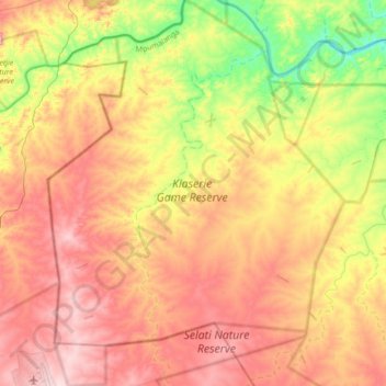
Klaserie Private Nature Reserve topographic map
Interactive map
Click on the map to display elevation.
Klaserie Private Nature Reserve topographic map, elevation, terrain
About this map
Name: Klaserie Private Nature Reserve topographic map, elevation, terrain.
Average elevation: 395 m
Minimum elevation: 253 m
Maximum elevation: 525 m
Other topographic maps
Click on a map to view its topography, its elevation and its terrain.
Hazyview
South Africa > Mpumalanga > Ehlanzeni District Municipality > Mbombela
Average elevation: 554 m
White River
South Africa > Mpumalanga > Ehlanzeni District Municipality > Mbombela
White River is located in the low altitude subtropical Lowveld climatic zone. Savannah and woodland scattered with granite outcrops form the indigenous habitat. Compared to other parts of South Africa, the climate is mild with good rainfall. Nevertheless, like the rest of South Africa, White River and its…
Average elevation: 902 m
Marloth Park
South Africa > Mpumalanga > Ehlanzeni District Municipality > Nkomazi
Average elevation: 220 m
Ngodwana
South Africa > Mpumalanga > Ehlanzeni District Municipality > Mbombela
Average elevation: 1,032 m
Crocodile Bridge Rest Camp
South Africa > Mpumalanga > Ehlanzeni District Municipality > Nkomazi
Average elevation: 179 m
Sabi Sands Game Reserve
South Africa > Mpumalanga > Ehlanzeni District Municipality
Average elevation: 385 m
Lowveld View
South Africa > Mpumalanga > Ehlanzeni District Municipality > Thaba Chweu Local Municipality > Frankfurt
Average elevation: 1,104 m
Blyderivierpoort Dam
South Africa > Mpumalanga > Ehlanzeni District Municipality > Thaba Chweu Local Municipality
Average elevation: 835 m
Thaba Chweu Ward 13
South Africa > Mpumalanga > Ehlanzeni District Municipality > Thaba Chweu Local Municipality
Average elevation: 1,458 m
Kanyamazane
South Africa > Mpumalanga > Ehlanzeni District Municipality > Mbombela
Average elevation: 637 m
Khutsong
South Africa > Mpumalanga > Ehlanzeni District Municipality > Thaba Chweu Local Municipality
Average elevation: 1,288 m
Lydenburg
South Africa > Mpumalanga > Ehlanzeni District Municipality > Thaba Chweu Local Municipality
Average elevation: 1,424 m
Barberton
South Africa > Mpumalanga > Ehlanzeni District Municipality > Umjindi Local Municipality
Average elevation: 917 m
Lower Sabie Rest Camp
South Africa > Mpumalanga > Ehlanzeni District Municipality > Nkomazi
Average elevation: 181 m
Pretoriuskop Rest Camp
South Africa > Mpumalanga > Ehlanzeni District Municipality > Mbombela
Average elevation: 594 m
Mashishing
South Africa > Mpumalanga > Ehlanzeni District Municipality > Thaba Chweu Local Municipality
Average elevation: 1,421 m
Kamagugu
South Africa > Mpumalanga > Ehlanzeni District Municipality > Mbombela
Average elevation: 685 m
Blyde River Canyon Nature Reserve
South Africa > Mpumalanga > Ehlanzeni District Municipality > Thaba Chweu Local Municipality
The Mogologolo (1,794 m), Mariepskop (1,944 m) and Hebronberg (1,767 m) massifs are partially included in the reserve. Elevation varies from 560 m to 1,944 m above sea level. Its resort areas are F.H. Odendaal and Swadeni, the latter only accessible from Limpopo province. The area of approximately 29,000…
Average elevation: 1,040 m
Mageng
South Africa > Mpumalanga > Ehlanzeni District Municipality > Mbombela
Average elevation: 601 m
Sabie
South Africa > Mpumalanga > Ehlanzeni District Municipality > Thaba Chweu Local Municipality
Average elevation: 1,150 m
Pilgrim's Rest
South Africa > Mpumalanga > Ehlanzeni District Municipality > Thaba Chweu Local Municipality
Average elevation: 1,352 m
Skukuza Rest Camp
South Africa > Mpumalanga > Ehlanzeni District Municipality > Mbombela
Average elevation: 282 m
Komatipoort
South Africa > Mpumalanga > Ehlanzeni District Municipality > Nkomazi
Average elevation: 173 m
Klipkoppie Dam
South Africa > Mpumalanga > Ehlanzeni District Municipality > Mbombela
Average elevation: 973 m
Malalane
South Africa > Mpumalanga > Ehlanzeni District Municipality > Nkomazi
Average elevation: 352 m
Mount Anderson
South Africa > Mpumalanga > Ehlanzeni District Municipality > Thaba Chweu Local Municipality > Mount Anderson
Average elevation: 1,173 m
Apara
South Africa > Mpumalanga > Ehlanzeni District Municipality > Thaba Chweu Local Municipality > Apara
Average elevation: 1,204 m
Tshabalala
South Africa > Mpumalanga > Ehlanzeni District Municipality > Mbombela
Average elevation: 559 m
Gutshwa
South Africa > Mpumalanga > Ehlanzeni District Municipality > Mbombela
Average elevation: 475 m
Driekoppies Dam
South Africa > Mpumalanga > Ehlanzeni District Municipality > Nkomazi
Average elevation: 322 m
Kanana
South Africa > Mpumalanga > Ehlanzeni District Municipality > Thaba Chweu Local Municipality
Average elevation: 1,273 m
Rocky Drift
South Africa > Mpumalanga > Ehlanzeni District Municipality > Mbombela
Average elevation: 848 m
Hectorspruit
South Africa > Mpumalanga > Ehlanzeni District Municipality > Nkomazi
Average elevation: 274 m
Thaba Chweu Local Municipality
South Africa > Mpumalanga > Ehlanzeni District Municipality
Average elevation: 1,207 m
Pienaar
South Africa > Mpumalanga > Ehlanzeni District Municipality > Mbombela
Average elevation: 676 m
Longmere Dam
South Africa > Mpumalanga > Ehlanzeni District Municipality > Mbombela > White River Country Estates
Average elevation: 963 m