
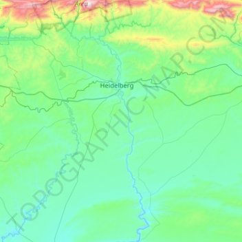
Duiwenhoks River topographic map
Interactive map
Click on the map to display elevation.
About this map
Name: Duiwenhoks River topographic map, elevation, terrain.
Average elevation: 226 m
Minimum elevation: -1 m
Maximum elevation: 1,477 m
Other topographic maps
Click on a map to view its topography, its elevation and its terrain.
George
South Africa > Western Cape > Garden Route District Municipality > George Local Municipality
Average elevation: 244 m
Rustig
South Africa > Western Cape > West Coast District Municipality > Cederberg Local Municipality
Average elevation: 239 m
Hermanus
South Africa > Western Cape > Overberg District Municipality > Overstrand Local Municipality
Average elevation: 87 m
Ladismith
South Africa > Western Cape > George
It is situated adjacent to a series of fertile, irrigated valleys, at an elevation of 550 m above sea level, at the southern base of the Swartberg. It is currently included in the southern Kannaland Local Municipality. The nearest towns are Calitzdorp to the east, Vanwyksdorp and Riversdale to the south and…
Average elevation: 605 m
Windmeul
South Africa > Western Cape > Cape Winelands District Municipality > Paarl
Average elevation: 198 m
Betty's Bay
South Africa > Western Cape > Overberg District Municipality > Overstrand Local Municipality
Average elevation: 210 m
Tsitsikamma National Park (Marine Reserve)
South Africa > Western Cape > George
Average elevation: 50 m
Napier
South Africa > Western Cape > Overberg District Municipality > Cape Agulhas Local Municipality
Average elevation: 170 m
Simondium
South Africa > Western Cape > Cape Winelands District Municipality > Drakenstein Local Municipality
Average elevation: 154 m
Hopefield
South Africa > Western Cape > West Coast District Municipality > Saldanha Bay Local Municipality
Average elevation: 58 m
Dianthus Street Park
South Africa > Western Cape > City of Cape Town > Somerset West
Average elevation: 89 m
Anysberg
South Africa > Western Cape > Central Karoo District Municipality > Laingsburg Local Municipality
Average elevation: 1,090 m
Paternoster
South Africa > Western Cape > West Coast District Municipality > Saldanha Bay Local Municipality
Average elevation: 20 m
Tankwa
South Africa > Western Cape > Cape Winelands District Municipality > Witzenberg Local Municipality
Average elevation: 381 m
Uniondale
South Africa > Western Cape > Garden Route District Municipality > George Local Municipality
Average elevation: 847 m
Eerste River
South Africa > Western Cape > Cape Winelands District Municipality > Stellenbosch Local Municipality
Average elevation: 379 m
Kleinbaai
South Africa > Western Cape > Overberg District Municipality > Overstrand Local Municipality
Average elevation: 15 m
Montagu
South Africa > Western Cape > Cape Winelands District Municipality > Langeberg Local Municipality
Average elevation: 434 m
Dwarskersbos
South Africa > Western Cape > West Coast District Municipality > Bergrivier Local Municipality
Average elevation: 5 m
Eendekuil
South Africa > Western Cape > West Coast District Municipality > Bergrivier Local Municipality
Average elevation: 118 m
Formosa Nature Reserve
South Africa > Western Cape > Sarah Baartman District Municipality > George
Average elevation: 568 m
Murraysburg
South Africa > Western Cape > Central Karoo District Municipality > Beaufort West Local Municipality
Average elevation: 1,219 m
Jacobsbaai
South Africa > Western Cape > West Coast District Municipality > Saldanha Bay Local Municipality
Average elevation: 24 m
Malmesbury
South Africa > Western Cape > West Coast District Municipality > Swartland Local Municipality
Average elevation: 174 m
Bredasdorp
South Africa > Western Cape > Overberg District Municipality > Cape Agulhas Local Municipality
Bredasdorp is situated at an elevation of between 40 and 120 metres (130 and 390 ft) on the slopes of the Heuningberg (Afrikaans for "Honey Mountain"). There is no significant watercourse flowing through the town, although the Kars Rivier flows past a few kilometres to the east.
Average elevation: 104 m
Voëlvlei Lake
South Africa > Western Cape > Cape Winelands District Municipality > Drakenstein Local Municipality
Average elevation: 159 m
Koringberg
South Africa > Western Cape > West Coast District Municipality > Swartland Local Municipality
Average elevation: 151 m
La Motte
South Africa > Western Cape > Cape Winelands District Municipality > Stellenbosch Local Municipality
Average elevation: 315 m
De Hoek
South Africa > Western Cape > West Coast District Municipality > Bergrivier Local Municipality
Average elevation: 162 m
Langvlei
South Africa > Western Cape > West Coast District Municipality > Bergrivier Local Municipality
Average elevation: 835 m
Jakkalskop
South Africa > Western Cape > Cape Winelands District Municipality > Witzenberg Local Municipality
Average elevation: 375 m
Bekbaai
South Africa > Western Cape > West Coast District Municipality > Saldanha Bay Local Municipality > Paternoster
Average elevation: 21 m
Wolseley
South Africa > Western Cape > Cape Winelands District Municipality > Witzenberg Local Municipality
Wolseley lies at an altitude of 260 metres (850 ft) on the watershed between the drainage basins of the Breede River, which flows south to the Indian Ocean, and the Berg River, which flows north to the Atlantic Ocean. It is 15 kilometres (9 mi) south of Tulbagh, 12 kilometres (7 mi) southwest of Ceres, and 35…
Average elevation: 271 m
Arniston
South Africa > Western Cape > Overberg District Municipality > Cape Agulhas Local Municipality
Average elevation: 13 m
McGregor
South Africa > Western Cape > Cape Winelands District Municipality > Langeberg Local Municipality
Average elevation: 314 m
Prince Albert Road
South Africa > Western Cape > Central Karoo District Municipality > Prince Albert Local Municipality
Average elevation: 622 m
Prince Albert
South Africa > Western Cape > Central Karoo District Municipality > Prince Albert Local Municipality
Average elevation: 656 m
Laingsburg
South Africa > Western Cape > Central Karoo District Municipality > Laingsburg Local Municipality
Average elevation: 703 m
Helderberg Nature Reserve
South Africa > Western Cape > City of Cape Town > Somerset West
Average elevation: 344 m
Prince Alfred Hamlet
South Africa > Western Cape > Cape Winelands District Municipality > Witzenberg Local Municipality
Average elevation: 514 m
Spitskop
South Africa > Western Cape > Cape Winelands District Municipality > Drakenstein Local Municipality
Average elevation: 694 m
Wemmershoek Dam
South Africa > Western Cape > Cape Winelands District Municipality > Drakenstein Local Municipality
Average elevation: 425 m
Wemmershoek Tafelberg
South Africa > Western Cape > Cape Winelands District Municipality > Drakenstein Local Municipality
Average elevation: 1,292 m
Groot-Drakenstein
South Africa > Western Cape > Cape Winelands District Municipality > Stellenbosch Local Municipality
Average elevation: 173 m
Witklip Dam
South Africa > Western Cape > Overberg District Municipality > Theewaterskloof Local Municipality
Average elevation: 687 m
Table Mountain (Maclear's beacon)
South Africa > Western Cape > City of Cape Town > Cape Town
Average elevation: 675 m
Baviaansberg
South Africa > Western Cape > Cape Winelands District Municipality > Witzenberg Local Municipality
Average elevation: 1,555 m
Steenboksberg
South Africa > Western Cape > Overberg District Municipality > Theewaterskloof Local Municipality
Average elevation: 469 m
Algeria
South Africa > Western Cape > West Coast District Municipality > Cederberg Local Municipality
Average elevation: 781 m
Hansiesberg
South Africa > Western Cape > Cape Winelands District Municipality > Witzenberg Local Municipality
Average elevation: 1,419 m
Stanford
South Africa > Western Cape > Overberg District Municipality > Overstrand Local Municipality
Average elevation: 107 m
Tandfontein Dam
South Africa > Western Cape > Cape Winelands District Municipality > Witzenberg Local Municipality
Average elevation: 869 m
Pankop
South Africa > Western Cape > West Coast District Municipality > Cederberg Local Municipality
Average elevation: 260 m
Merweville
South Africa > Western Cape > Central Karoo District Municipality > Beaufort West Local Municipality
Average elevation: 735 m
Touws River
South Africa > Western Cape > Cape Winelands District Municipality > Breede Valley Local Municipality
Touws River is located at an elevation of 770 metres (2,530 ft) on the southwestern edge of the Great Karoo, east of the Hex River Mountains and north of the Langeberg, at the point where the Donkeys River flows into the Touws River. It lies just to the south of the N1 highway, 180 kilometres (110 mi) by road…
Average elevation: 822 m
MTO Jonkershoek
South Africa > Western Cape > Cape Winelands District Municipality > Stellenbosch Local Municipality
Average elevation: 522 m
Stellenbosch
South Africa > Western Cape > Cape Winelands District Municipality > Stellenbosch
Stellenbosch is 53 km (33 mi) east of Cape Town via National Route N1. Stellenbosch is in a hilly region of the Cape Winelands, and is sheltered in a valley at an average elevation of 136 m (446 ft), flanked on the west by Papegaaiberg (Afrikaans: Parrot Mountain), which is actually a hill. To the south is…
Average elevation: 222 m
Breede River
South Africa > Western Cape > Cape Winelands District Municipality > Langeberg Local Municipality
Average elevation: 170 m
Vredenburg
South Africa > Western Cape > West Coast District Municipality > Saldanha Bay Local Municipality
Average elevation: 91 m
Silvermist Estate
South Africa > Western Cape > City of Cape Town > Cape Town
Average elevation: 272 m
Oudtshoorn
South Africa > Western Cape > Garden Route District Municipality > Oudtshoorn
Average elevation: 354 m
Riebeek-Wes
South Africa > Western Cape > West Coast District Municipality > Swartland Local Municipality
Average elevation: 262 m
Cape Peninsula
South Africa > Western Cape > City of Cape Town > Simon's Town
Average elevation: 189 m
Keurboomsriver Nature Reserve
South Africa > Western Cape > Garden Route District Municipality > Bitou Local Municipality
Average elevation: 144 m
Suurbraak
South Africa > Western Cape > Overberg District Municipality > Swellendam Local Municipality
Average elevation: 171 m
Stormsvlei
South Africa > Western Cape > Overberg District Municipality > Swellendam Local Municipality
Average elevation: 148 m
Riebeek-Kasteel
South Africa > Western Cape > West Coast District Municipality > Swartland Local Municipality
Average elevation: 186 m