
Free State topographic map
Click on the map to display elevation.
Free State
The Free State is situated on a succession of flat grassy plains sprinkled with pastureland, resting on a general elevation of 3,800 feet only broken by the occasional hill or kopje. The rich soil and pleasant climate allow for a thriving agricultural industry. With more than 30,000 farms, which produce over 70% of the country's grain, it is known locally as South Africa's breadbasket.
About this map
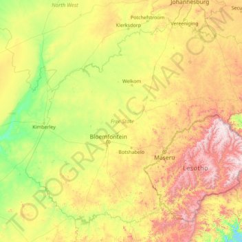
Name: Free State topographic map, elevation, terrain.
Location: Free State, South Africa (-30.69408 24.34662 -26.66874 29.78513)
Average elevation: 1,499 m
Minimum elevation: 980 m
Maximum elevation: 3,379 m
Other topographic maps
Click on a map to view its topography, its elevation and its terrain.
Cape Town
South Africa > Western Cape > City of Cape Town
The Cape Peninsula is 52 km long from Mouille Point in the north to Cape Point in the south, with an area of about 470 km2, and it displays more topographical variety than other similar sized areas in southern Africa, and consequently spectacular scenery. There are diverse low-nutrient soils, large rocky…
Average elevation: 53 m
Nquthu
South Africa > KwaZulu-Natal > Umzinyathi District Municipality > Nquthu Local Municipality
Average elevation: 1,175 m
Johannesburg
South Africa > Gauteng > City of Johannesburg Metropolitan Municipality
Johannesburg is located in the eastern plateau area of South Africa known as the Highveld, at an elevation of 1,753 metres (5,751 ft). The former Central Business District is located on the southern side of the prominent ridge called the Witwatersrand (English: White Water's Ridge) and the terrain falls to the…
Average elevation: 1,615 m
Hermanus
South Africa > Western Cape > Overberg District Municipality > Overstrand Local Municipality
Average elevation: 87 m
Graaff-Reinet
South Africa > Eastern Cape > Sarah Baartman District Municipality > Camdeboo Local Municipality
Average elevation: 873 m
Cape Town
South Africa > Western Cape > City of Cape Town
The Cape Peninsula is 52 km long from Mouille Point in the north to Cape Point in the south, with an area of about 470 km2, and it displays more topographical variety than other similar sized areas in southern Africa, and consequently spectacular scenery. There are diverse low-nutrient soils, large rocky…
Average elevation: 53 m
Bloemfontein
South Africa > Free State > Mangaung Metropolitan Municipality
Situated at an elevation of 1,395 m (4,577 ft) above sea level, the city is home to approximately 520,000 residents and forms part of the Mangaung Metropolitan Municipality which has a population of 747,431. It was one of the host cities for the 2010 FIFA World Cup.
Average elevation: 1,374 m
Johannesburg
South Africa > Gauteng > City of Johannesburg Metropolitan Municipality
Johannesburg is located in the eastern plateau area of South Africa known as the Highveld, at an elevation of 1,753 metres (5,751 ft). The former Central Business District is located on the southern side of the prominent ridge called the Witwatersrand (English: White Water's Ridge) and the terrain falls to the…
Average elevation: 1,615 m
Piketberg
South Africa > Western Cape > West Coast District Municipality > Bergrivier Local Municipality
Average elevation: 265 m
Mossel Bay
South Africa > Western Cape > George
To the east, the land slopes upwards towards the wave-cut platform (average elevation 245 metres) that characterises the more lush all-year-round rainfall area of the Garden Route. Here the land is mostly covered by grass and farmlands. The deep sandy soils of the western portion of the municipal area also…
Average elevation: 16 m
Phuthaditjhaba
South Africa > Free State > Thabo Mofutsanyana District Municipality > Maluti-a-Phofung Local Municipality
Average elevation: 1,736 m
Table Mountain
South Africa > Western Cape > City of Cape Town > Cape Town
Table Mountain is at the northern end of a sandstone mountain range that forms the spine of the Cape Peninsula that terminates approximately 50 kilometres (30 mi) to the south at the Cape of Good Hope and Cape Point. Immediately to the south of Table Mountain is a rugged "plateau" at a somewhat lower elevation…
Average elevation: 583 m
Vaal Dam
South Africa > Free State > Fezile Dabi District Municipality > Metsimaholo Local Municipality > Deneysville
Average elevation: 1,481 m
Lebowakgomo
South Africa > Limpopo > Capricorn District Municipality > Lepelle-Nkumpi Local Municipality
Average elevation: 1,017 m
Redelinghuys
South Africa > Western Cape > West Coast District Municipality > Bergrivier Local Municipality
Average elevation: 106 m
Dealesville
South Africa > Free State > Lejweleputswa District Municipality > Tokologo Local Municipality
Average elevation: 1,265 m
Baviaanshoek
South Africa > Western Cape > Cape Winelands District Municipality > Witzenberg Local Municipality
Average elevation: 1,181 m
Kuruman
South Africa > Northern Cape > John Taolo Gaetsewe District Municipality > Ga-Segonyana Local Municipality
Average elevation: 1,335 m
Nqweba Dam
South Africa > Eastern Cape > Sarah Baartman District Municipality > Camdeboo Local Municipality > Graaf-Reinet
Average elevation: 815 m
Gqeberha
South Africa > Eastern Cape > Nelson Mandela Bay Metropolitan Municipality
Average elevation: 37 m
Stellenbosch
South Africa > Western Cape > Cape Winelands District Municipality > Stellenbosch Local Municipality
Stellenbosch is 53 km (33 mi) east of Cape Town via National Route N1. Stellenbosch is in a hilly region of the Cape Winelands, and is sheltered in a valley at an average elevation of 136 m (446 ft), flanked on the west by Papegaaiberg (Afrikaans: Parrot Mountain), which is actually a hill. To the south is…
Average elevation: 287 m
Clanwilliam
South Africa > Western Cape > West Coast District Municipality > Cederberg Local Municipality
Clanwilliam is situated at an elevation of 100 metres (330 ft), between the western slopes of the Cederberg mountains and the east bank of the Olifants River, which is impounded there by the Clanwilliam Dam. It is located just off the N7 national road, which runs from Cape Town to the Namibian border, and on…
Average elevation: 162 m
Hillcrest
South Africa > KwaZulu-Natal > eThekwini Metropolitan Municipality
Hillcrest is situated in the Upper Highway Area of Durban, approximately 32 kilometres (20 mi) north-west of the city and is bordered by Gillitts and Everton to the east, Waterfall to the north-east and Botha's Hill and Assagay to the north-west. It lies at an altitude of approximately 680 m (2231 ft) above…
Average elevation: 625 m
Pretoria
South Africa > Gauteng > City of Tshwane Metropolitan Municipality
Pretoria is situated approximately 55 km (34 mi) north-northeast of Johannesburg in the northeast of South Africa, in a transitional belt between the plateau of the Highveld to the south and the lower-lying Bushveld to the north. It lies at an altitude of about 1,339 m (4,393 ft) above sea level, in a warm,…
Average elevation: 1,363 m
Tugela Ferry
South Africa > KwaZulu-Natal > Umzinyathi District Municipality > Msinga Local Municipality
Average elevation: 643 m
Magaliesberg Biosphere Reserve
The reserve includes a variety of landscapes including slopes, cliffs, crests, kloofs, rivers, wetlands and valleys. Although the area covers a diverse geological area, it consists mainly of the Magaliesberg mountain complex comprising two geological formations: the Transvaal System and the Bushveld Igneous…
Average elevation: 1,366 m
Mtubatuba
South Africa > KwaZulu-Natal > Umkhanyakude District Municipality > Mtubatuba Local Municipality
Average elevation: 64 m
Ntshongweni
South Africa > KwaZulu-Natal > King Cetswayo District Municipality > Nkandla Local Municipality
Average elevation: 682 m
Phalaborwa
South Africa > Limpopo > Mopani District Municipality > Ba-Phalaborwa Local Municipality
Average elevation: 419 m
Pongola
South Africa > KwaZulu-Natal > Zululand District Municipality > uPhongolo Local Municipality
Average elevation: 291 m
Hogsback
South Africa > Eastern Cape > Amathole District Municipality > Nkonkobe Local Municipality
Average elevation: 1,217 m
Alberton
South Africa > Gauteng > City of Ekurhuleni Metropolitan Municipality
Alberton lies at an elevation of approximately 1,570 m (5,150 ft) above sea level on the banks of the Natal Spruit, approximately 11 km south-east of Johannesburg CBD, 59 km south of Pretoria and 49 km north-east of Vereeniging. Organisationally and administratively, it is included in the City of Ekurhuleni…
Average elevation: 1,617 m
Pinetown
South Africa > KwaZulu-Natal > eThekwini Metropolitan Municipality
Topographically, Pinetown is generally hilly with the exception of the central business district which is relatively flatter by comparison to the surrounding suburban areas. The notable high-lying areas in the eastern parts of Pinetown include Cowies Hill and the New Germany Nature Reserve reaching…
Average elevation: 356 m
Ficksburg
South Africa > Free State > Thabo Mofutsanyana District Municipality > Setsoto Local Municipality
Average elevation: 1,617 m
Standerton
South Africa > Mpumalanga > Gert Sibande > Lekwa Local Municipality
Average elevation: 1,554 m
Boksburg
South Africa > Gauteng > City of Ekurhuleni Metropolitan Municipality
Average elevation: 1,637 m
Durbanville
South Africa > Western Cape > City of Cape Town
Durbanville is situated in the northern suburbs of Cape Town, approximately 28 kilometres (17.4 mi) north-east of the city, bordered by Bellville to the south, Brackenfell to the south-east and Kraaifontein to the east. It lies at an altitude of between 100 m (328 ft) to 240 m (787 ft), in the vast rolling…
Average elevation: 157 m
Jansenville
South Africa > Eastern Cape > Sarah Baartman District Municipality > Ikwezi Local Municipality
Average elevation: 448 m
Mogwase
South Africa > North West > Bojanala Platinum District Municipality > Moses Kotane Local Municipality
Average elevation: 1,095 m
Coronation Park
South Africa > Gauteng > West Rand District Municipality > Krugersdorp
Average elevation: 1,737 m
Kamieskroon
South Africa > Northern Cape > Namakwa District Municipality > Kamiesberg Local Municipality
Kamieskroon is a small town in the Kamiesberg Local Municipality, lying in the foothills of the Kamiesberge at an elevation of approximately 800 m (2 600 ft). The town is more or less in the centre of Namaqualand, about 70 km (43 mi) to the south of Springbok, Northern Cape, South Africa. It is known mainly…
Average elevation: 789 m
Underberg
South Africa > KwaZulu-Natal > Sisonke District Municipality > Kwa Sani Local Municipality
Average elevation: 1,552 m
Manyii
South Africa > Limpopo > Vhembe District Municipality > Makhado Local Municipality
Average elevation: 912 m
Vygeboom Dam
South Africa > Mpumalanga > Gert Sibande > Albert Luthuli Local Municipality
Average elevation: 1,056 m
Evaton
South Africa > Gauteng > Sedibeng District Municipality > Emfuleni Local Municipality
Average elevation: 1,522 m
Schweizer-Reneke
South Africa > North West > Dr Ruth Segomotsi Mompati District Municipality > Mamusa Local Municipality
Average elevation: 1,318 m
Stilfontein
South Africa > North West > Dr Kenneth Kaunda District Municipality > Matlosana Local Municipality
Average elevation: 1,346 m
Pietermaritzburg
South Africa > KwaZulu-Natal > uMgungundlovu District Municipality
Average elevation: 853 m
Rustenburg
South Africa > North West > Bojanala Platinum District Municipality
Rustenburg has a humid subtropical climate (Köppen Cwa), with a relatively high degree of diurnal temperature variation due to the high elevation. It has very warm summers (from December to February) and mild winters (from June to August). Due to the altitude, summers are not quite as hot as one might expect.…
Average elevation: 1,217 m
Franschhoek
South Africa > Western Cape > Cape Winelands District Municipality > Stellenbosch Local Municipality
Average elevation: 502 m
Kanyamazane
South Africa > Mpumalanga > Ehlanzeni District Municipality > Mbombela
Average elevation: 637 m
Klerksdorp
South Africa > North West > Dr Kenneth Kaunda District Municipality
Average elevation: 1,346 m
Vryburg
South Africa > North West > Dr Ruth Segomotsi Mompati District Municipality > Naledi Local Municipality
Average elevation: 1,205 m
Sasolburg
South Africa > Free State > Fezile Dabi District Municipality > Metsimaholo Local Municipality
Sasolburg is at a high altitude with a fairly dry climate and large seasonal temperature variation. It is situated on the banks of the Vaal River, which separates the Free State from the former Transvaal Province, and is not far from the Vaal Dam where excellent windsurfing spots can be found.
Average elevation: 1,469 m
Stanger / KwaDukuza
South Africa > KwaZulu-Natal > iLembe District Municipality > KwaDukuza Local Municipality
Average elevation: 96 m
Springbok
South Africa > Northern Cape > Namakwa District Municipality > Nama Khoi Local Municipality
The town lies at an elevation of 1,007 metres (3,304 feet) in a narrow valley between the high granite domes of the Klein Koperberge (Small Copper Mountains). This name gives away the reason for the early settlement which gradually turned into a major commercial and administrative centre for copper mining…
Average elevation: 927 m
De Aar
South Africa > Northern Cape > Pixley ka Seme District Municipality > Emthanjeni Local Municipality
Average elevation: 1,257 m
Groblersdal
South Africa > Limpopo > Sekhukhune District Municipality > Elias Motsoaledi Local Municipality
Average elevation: 939 m
Ixopo
South Africa > KwaZulu-Natal > Sisonke District Municipality > Ubuhlebezwe Local Municipality
Average elevation: 1,009 m
Richards Bay
South Africa > KwaZulu-Natal > King Cetswayo District Municipality
Average elevation: 31 m
Willowmore
South Africa > Eastern Cape > Sarah Baartman District Municipality > Baviaans Local Municipality
Average elevation: 868 m
Bela-Bela
South Africa > Limpopo > Waterberg District Municipality > Bela Bela Local Municipality
Average elevation: 1,158 m
Burgersfort
South Africa > Limpopo > Sekhukhune District Municipality > Greater Tubatse Local Municipality
Average elevation: 810 m
Laingsburg
South Africa > Western Cape > Central Karoo District Municipality > Laingsburg Local Municipality
Average elevation: 703 m
Lephalale
South Africa > Limpopo > Waterberg District Municipality > Lephalale Local Municipality
Average elevation: 831 m
Vredendal
South Africa > Western Cape > West Coast District Municipality > Matzikama Local Municipality
Average elevation: 51 m
Butterworth
South Africa > Eastern Cape > Amathole District Municipality > Mnquma Local Municipality
Average elevation: 599 m
Bothaville
South Africa > Free State > Lejweleputswa District Municipality > Nala Local Municipality
Average elevation: 1,287 m
Port St Johns
South Africa > Eastern Cape > O.R. Tambo District Municipality > Port St Johns Local Municipality
Average elevation: 85 m
Prince Albert
South Africa > Western Cape > Central Karoo District Municipality > Prince Albert Local Municipality
Average elevation: 656 m
Vredenburg
South Africa > Western Cape > West Coast District Municipality > Saldanha Bay Local Municipality
Average elevation: 91 m
Thabazimbi
South Africa > Limpopo > Waterberg District Municipality > Thabazimbi Local Municipality
Average elevation: 1,077 m
Lenasia
South Africa > Gauteng > City of Johannesburg Metropolitan Municipality
Average elevation: 1,590 m
Potchefstroom
South Africa > North West > Dr Kenneth Kaunda District Municipality
Potchefstroom has hosted two World Cup-winning teams (in cricket and football), and is a home away from home for international athletes and teams. At 1,400 metres (4,600 ft) altitude, it provides a good balance between altitude and quality training. The city has no large factories, and good air quality.…
Average elevation: 1,393 m