
Oklahoma topographic map
Interactive map
Click on the map to display elevation.
About this map
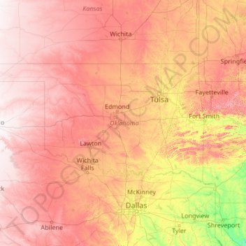
Name: Oklahoma topographic map, elevation, terrain.
Location: Oklahoma, United States (33.61915 -103.00244 37.00230 -94.43121)
Average elevation: 408 m
Minimum elevation: 30 m
Maximum elevation: 1,082 m
The semi-arid high plains in the state's northwestern corner harbor few natural forests; the region has a rolling to flat landscape with intermittent canyons and mesa ranges like the Glass Mountains. Partial plains interrupted by small, sky island mountain ranges like the Antelope Hills and the Wichita Mountains dot southwestern Oklahoma; transitional prairie and oak savannas cover the central portion of the state. The Ozark and Ouachita Mountains rise from west to east over the state's eastern third, gradually increasing in elevation in an eastward direction.
Other topographic maps
Click on a map to view its topography, its elevation and its terrain.
Rohnert Park
United States > California > Sonoma County
Rohnert Park, Sonoma County, California, United States
Average elevation: 39 m
Westbrook
United States > Texas > Mitchell County
Westbrook, Mitchell County, Texas, 79565, United States
Average elevation: 657 m
Yellowstone County
Yellowstone County, Montana, United States
Average elevation: 1,067 m
Sevierville
United States > Tennessee > Sevier County
Sevierville, Sevier County, East Tennessee, Tennessee, United States
Average elevation: 313 m
Siloam
United States > New Jersey > Monmouth County > Freehold Township
Siloam, Freehold Township, Monmouth County, New Jersey, United States
Average elevation: 44 m
Amherst County
Amherst County, Virginia, United States
Average elevation: 329 m
Clifton
United States > New Jersey > Passaic County
Clifton, Passaic County, New Jersey, United States
Average elevation: 56 m
Chantilly
United States > Virginia > Fairfax County
Chantilly, Fairfax County, Virginia, United States
Average elevation: 96 m
Shanty Town
United States > Minnesota > Olmsted County
Shanty Town, Olmsted County, Minnesota, United States
Average elevation: 353 m
Loch Sheldrake
United States > New York > Sullivan County
Loch Sheldrake, Town of Fallsburg, Sullivan County, New York, United States
Average elevation: 448 m
Kyles
United States > Ohio > Butler County
Kyles, Liberty Township, Butler County, Ohio, 45050, United States
Average elevation: 222 m
Barrington
United States > Rhode Island > Bristol County
Barrington, Bristol County, Rhode Island, 02806, United States
Average elevation: 4 m
Pasco
United States > Washington > Franklin County
Pasco, Franklin County, Washington, 99301, United States
Average elevation: 141 m
Parsippany-Troy Hills
United States > New Jersey > Morris County
Parsippany-Troy Hills, Morris County, New Jersey, United States
Average elevation: 113 m
Black Rock
United States > Arkansas > Lawrence County
Black Rock, Lawrence County, Arkansas, 72415, United States
Average elevation: 90 m
Trussville Manor
United States > Alabama > Jefferson County > Trussville
Trussville Manor, Trussville, Jefferson County, Alabama, 35173, United States
Average elevation: 237 m
Rosedale
United States > California > Kern County
Rosedale, Kern County, California, United States
Average elevation: 113 m
Redoubt
United States > Alaska > Anchorage
Redoubt, Anchorage, Alaska, United States
Average elevation: 49 m
Flagstaff
United States > Arizona > Coconino County
Flagstaff, Coconino County, Arizona, United States
Average elevation: 2,176 m
Campbell County
Campbell County, Kentucky, United States
Average elevation: 223 m
Village of Clayville
United States > New York > Oneida County
Village of Clayville, Town of Paris, Oneida County, New York, United States
Average elevation: 361 m
Athens-Clarke County Unified Government
United States > Georgia > Athens-Clarke County
Athens-Clarke County Unified Government, Athens-Clarke County, Georgia, United States
Average elevation: 219 m
Fife Lake
United States > Michigan > Grand Traverse County
Fife Lake, Fife Lake Township, Grand Traverse County, Michigan, United States
Average elevation: 317 m
Riverbanks
United States > South Carolina > Richland County > Columbia
Riverbanks, Columbia, Richland County, South Carolina, 29202, United States
Average elevation: 69 m
Laurel
United States > Maryland > Prince George's County
Laurel, Prince George's County, Maryland, 20707, United States
Average elevation: 62 m
Austin
United States > Texas > Travis County
Austin, Travis County, Texas, United States
Average elevation: 216 m
Charlottesville
Charlottesville, Virginia, 22902, United States
Average elevation: 173 m
Kingsport
United States > Tennessee > Sullivan County
Kingsport, Sullivan County, East Tennessee, Tennessee, United States
Average elevation: 453 m
Codell
United States > Kansas > Rooks County
Codell, Rooks County, Kansas, United States
Average elevation: 620 m
Eliot
United States > Maine > York County
Eliot, York County, Maine, 03903, United States
Average elevation: 17 m
Cherokee County
United States > North Carolina
Cherokee County, North Carolina, United States
Average elevation: 655 m
Pittsburgh
United States > Pennsylvania > Allegheny County
Pittsburgh, Allegheny County, Pennsylvania, United States
Average elevation: 303 m
West Park
United States > Florida > Broward County > West Park
West Park, Broward County, Florida, United States
Average elevation: 8 m
Philadelphia
United States > Pennsylvania > Philadelphia County
Philadelphia, Philadelphia County, Pennsylvania, United States
Average elevation: 44 m
Berkeley
United States > California > Alameda County
Berkeley, Alameda County, California, United States
Average elevation: 109 m
Ann Arbor
United States > Michigan > Washtenaw County
Ann Arbor, Washtenaw County, Michigan, United States
Average elevation: 272 m
Seattle
United States > Washington > King County
Seattle, King County, Washington, United States
Average elevation: 40 m
Savannah
United States > Georgia > Chatham County
Savannah, Chatham County, Georgia, United States
Average elevation: 4 m
Quincy
United States > Washington > Grant County
Quincy, Grant County, Washington, United States
Average elevation: 400 m
St. James
United States > Minnesota > Watonwan County
St. James, Watonwan County, Minnesota, 56081, United States
Average elevation: 328 m
Jefferson County
Jefferson County, Colorado, United States
Average elevation: 2,389 m
Lemont
United States > Illinois > Cook County
Lemont, Lemont Township, Cook County, Illinois, 60439, United States
Average elevation: 209 m
Lighthouse Bay at the Brooks
United States > Florida > Lee County
Lighthouse Bay at the Brooks, Lee County, Florida, 34136, United States
Average elevation: 6 m
Flagstaff
United States > Arizona > Coconino County
Flagstaff, Coconino County, Arizona, United States
Average elevation: 2,176 m
Gila Bend
United States > Arizona > Maricopa County
Gila Bend, Maricopa County, Arizona, United States
Average elevation: 257 m
Rifle
United States > Colorado > Garfield County
Rifle, Garfield County, Colorado, 81650, United States
Average elevation: 1,731 m