
Limpopo topographic map
Click on the map to display elevation.
About this map
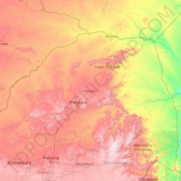
Name: Limpopo topographic map, elevation, terrain.
Location: Limpopo, South Africa (-25.42284 26.40754 -22.12503 31.88439)
Average elevation: 887 m
Minimum elevation: 107 m
Maximum elevation: 2,306 m
Other topographic maps
Click on a map to view its topography, its elevation and its terrain.
Cape Town
South Africa > Western Cape > City of Cape Town
The Cape Peninsula is 52 km long from Mouille Point in the north to Cape Point in the south, with an area of about 470 km2, and it displays more topographical variety than other similar sized areas in southern Africa, and consequently spectacular scenery. There are diverse low-nutrient soils, large rocky…
Average elevation: 53 m
Pretoria
South Africa > Gauteng > City of Tshwane Metropolitan Municipality
Pretoria is situated approximately 55 km (34 mi) north-northeast of Johannesburg in the northeast of South Africa, in a transitional belt between the plateau of the Highveld to the south and the lower-lying Bushveld to the north. It lies at an altitude of about 1,339 m (4,393 ft) above sea level, in a warm,…
Average elevation: 1,363 m
Johannesburg
South Africa > Gauteng > City of Johannesburg Metropolitan Municipality
Johannesburg is located in the eastern plateau area of South Africa known as the Highveld, at an elevation of 1,753 metres (5,751 ft). The former Central Business District is located on the southern side of the prominent ridge called the Witwatersrand (English: White Water's Ridge) and the terrain falls to the…
Average elevation: 1,615 m
Cape Town
South Africa > Western Cape > City of Cape Town
The Cape Peninsula is 52 km long from Mouille Point in the north to Cape Point in the south, with an area of about 470 km2, and it displays more topographical variety than other similar sized areas in southern Africa, and consequently spectacular scenery. There are diverse low-nutrient soils, large rocky…
Average elevation: 53 m
Clanwilliam
South Africa > Western Cape > West Coast District Municipality > Cederberg Local Municipality
Clanwilliam is situated at an elevation of 100 metres (330 ft), between the western slopes of the Cederberg mountains and the east bank of the Olifants River, which is impounded there by the Clanwilliam Dam. It is located just off the N7 national road, which runs from Cape Town to the Namibian border, and on…
Average elevation: 162 m
Hermanus
South Africa > Western Cape > Overberg District Municipality > Overstrand Local Municipality
Average elevation: 87 m
Port Edward
South Africa > KwaZulu-Natal > Ugu District Municipality > Hibiscus Coast Local Municipality
Average elevation: 42 m
Randburg
South Africa > Gauteng > City of Johannesburg Metropolitan Municipality
Average elevation: 1,567 m
Kayser's Beach
South Africa > Eastern Cape > Buffalo City Metropolitan Municipality
Average elevation: 28 m
Mankweng
South Africa > Limpopo > Capricorn District Municipality > Polokwane Local Municipality
Average elevation: 1,300 m
Pietermaritzburg
South Africa > KwaZulu-Natal > uMgungundlovu District Municipality
Average elevation: 853 m
Steelpoort
South Africa > Limpopo > Sekhukhune District Municipality > Greater Tubatse Local Municipality
Average elevation: 854 m
Stellenbosch
South Africa > Western Cape > Cape Winelands District Municipality > Stellenbosch Local Municipality
Stellenbosch is 53 km (33 mi) east of Cape Town via National Route N1. Stellenbosch is in a hilly region of the Cape Winelands, and is sheltered in a valley at an average elevation of 136 m (446 ft), flanked on the west by Papegaaiberg (Afrikaans: Parrot Mountain), which is actually a hill. To the south is…
Average elevation: 287 m
Midrand
South Africa > Gauteng > City of Johannesburg Metropolitan Municipality
Average elevation: 1,542 m
Vaal Dam
South Africa > Free State > Fezile Dabi District Municipality > Metsimaholo Local Municipality > Deneysville
Average elevation: 1,481 m
Sebokeng
South Africa > Gauteng > Sedibeng District Municipality > Emfuleni Local Municipality
Average elevation: 1,523 m
Mamelodi
South Africa > Gauteng > City of Tshwane Metropolitan Municipality
Average elevation: 1,319 m
Ennerdale
South Africa > Gauteng > City of Johannesburg Metropolitan Municipality
Average elevation: 1,630 m
Gqeberha
South Africa > Eastern Cape > Nelson Mandela Bay Metropolitan Municipality
Average elevation: 37 m
Vredenburg
South Africa > Western Cape > West Coast District Municipality > Saldanha Bay Local Municipality
Average elevation: 91 m
Port Shepstone
South Africa > KwaZulu-Natal > Ugu District Municipality > Hibiscus Coast Local Municipality
Port Shepstone's topography is characterised by a rugged/hilly terrain with the Central Business District (CBD) lying on a large hill overlooking the Indian Ocean. Port Shepstone proper (excluding its extensions) is bordered by the uMzimkhulu River to the north and the N2 freeway to the east and is also…
Average elevation: 33 m
White River
South Africa > Mpumalanga > Ehlanzeni District Municipality > Mbombela
White River is located in the low altitude subtropical Lowveld climatic zone. Savannah and woodland scattered with granite outcrops form the indigenous habitat. Compared to other parts of South Africa, the climate is mild with good rainfall. Nevertheless, like the rest of South Africa, White River and its…
Average elevation: 902 m
Vanderbijlpark
South Africa > Gauteng > Sedibeng District Municipality > Emfuleni Local Municipality
Vanderbijlpark is situated on the highveld of South Africa, at an altitude of 1,500 meters on the banks of the Vaal River. Summers in the city are warm to hot with an average high between 31 and 35°C, and an average low between 15 and 22°C. Winters in the city are cool to warm with an average high of between…
Average elevation: 1,474 m
Umhlanga Rocks
South Africa > KwaZulu-Natal > eThekwini Metropolitan Municipality
Average elevation: 45 m
Mookgophong
South Africa > Limpopo > Waterberg District Municipality > Mookgopong Local Municipality
Average elevation: 1,115 m
eLukwatini
South Africa > Mpumalanga > Gert Sibande > Albert Luthuli Local Municipality
Average elevation: 1,033 m
Rhodes
South Africa > Eastern Cape > Joe Gqabi District Municipality > Senqu Local Municipality
Average elevation: 2,067 m
Cofimvaba
South Africa > Eastern Cape > Chris Hani District Municipality > Intsika Yethu Local Municipality
Average elevation: 997 m
Ulundi
South Africa > KwaZulu-Natal > Zululand District Municipality > Ulundi Local Municipality
Average elevation: 586 m
Madadeni
South Africa > KwaZulu-Natal > Amajuba District Municipality > Newcastle Local Municipality
Average elevation: 1,196 m
Johannesburg Botanical Gardens
South Africa > Gauteng > City of Johannesburg Metropolitan Municipality > Randburg
Average elevation: 1,633 m
Margate
South Africa > KwaZulu-Natal > Ugu District Municipality > Hibiscus Coast Local Municipality
Average elevation: 45 m
Babanango
South Africa > KwaZulu-Natal > Zululand District Municipality > Ulundi Local Municipality
Average elevation: 1,260 m
Nkowankowa
South Africa > Limpopo > Mopani District Municipality > Greater Tzaneen Local Municipality
Average elevation: 544 m
Groblersdal
South Africa > Limpopo > Sekhukhune District Municipality > Elias Motsoaledi Local Municipality
Average elevation: 939 m
Bloemfontein
South Africa > Free State > Mangaung Metropolitan Municipality
Situated at an elevation of 1,395 m (4,577 ft) above sea level, the city is home to approximately 520,000 residents and forms part of the Mangaung Metropolitan Municipality which has a population of 747,431. It was one of the host cities for the 2010 FIFA World Cup.
Average elevation: 1,374 m
Magaliesberg Biosphere Reserve
The reserve includes a variety of landscapes including slopes, cliffs, crests, kloofs, rivers, wetlands and valleys. Although the area covers a diverse geological area, it consists mainly of the Magaliesberg mountain complex comprising two geological formations: the Transvaal System and the Bushveld Igneous…
Average elevation: 1,366 m
Jansenville
South Africa > Eastern Cape > Sarah Baartman District Municipality > Ikwezi Local Municipality
Average elevation: 448 m
Mtubatuba
South Africa > KwaZulu-Natal > Umkhanyakude District Municipality > Mtubatuba Local Municipality
Average elevation: 64 m
Klerksdorp
South Africa > North West > Dr Kenneth Kaunda District Municipality
Average elevation: 1,346 m
Laingsburg
South Africa > Western Cape > Central Karoo District Municipality > Laingsburg Local Municipality
Average elevation: 703 m
Thabazimbi
South Africa > Limpopo > Waterberg District Municipality > Thabazimbi Local Municipality
Average elevation: 1,077 m
Pongola
South Africa > KwaZulu-Natal > Zululand District Municipality > uPhongolo Local Municipality
Average elevation: 291 m
Johannesburg
South Africa > Gauteng > City of Johannesburg Metropolitan Municipality
Johannesburg is located in the eastern plateau area of South Africa known as the Highveld, at an elevation of 1,753 metres (5,751 ft). The former Central Business District is located on the southern side of the prominent ridge called the Witwatersrand (English: White Water's Ridge) and the terrain falls to the…
Average elevation: 1,615 m
Hartbeespoort Dam
South Africa > North West > Bojanala Platinum District Municipality > Madibeng Local Municipality > Kosmos
Average elevation: 1,254 m
Beaufort West
South Africa > Western Cape > Central Karoo District Municipality > Beaufort West Local Municipality
Average elevation: 854 m
Phuthaditjhaba
South Africa > Free State > Thabo Mofutsanyana District Municipality > Maluti-a-Phofung Local Municipality
Average elevation: 1,736 m
Clarens
South Africa > Free State > Thabo Mofutsanyana District Municipality > Dihlabeng Local Municipality
Average elevation: 1,874 m
Table Mountain
South Africa > Western Cape > City of Cape Town > Cape Town
Table Mountain is at the northern end of a sandstone mountain range that forms the spine of the Cape Peninsula that terminates approximately 50 kilometres (30 mi) to the south at the Cape of Good Hope and Cape Point. Immediately to the south of Table Mountain is a rugged "plateau" at a somewhat lower elevation…
Average elevation: 583 m
Roodepoort
South Africa > Gauteng > City of Johannesburg Metropolitan Municipality
Average elevation: 1,593 m
Vrede
South Africa > Free State > Thabo Mofutsanyana District Municipality > Phumelela Local Municipality
Average elevation: 1,678 m
KwaMakhutha
South Africa > KwaZulu-Natal > eThekwini Metropolitan Municipality
Average elevation: 90 m
Sandton
South Africa > Gauteng > City of Johannesburg Metropolitan Municipality
Average elevation: 1,583 m
Dundee
South Africa > KwaZulu-Natal > Umzinyathi District Municipality > Endumeni Local Municipality
Average elevation: 1,263 m
Elandsrand
South Africa > North West > Bojanala Platinum District Municipality > Madibeng Local Municipality
Average elevation: 1,141 m
Malavuwe
South Africa > Limpopo > Vhembe District Municipality > Thulamela Local Municipality
Average elevation: 522 m
Onrus River
South Africa > Western Cape > Overberg District Municipality > Overstrand Local Municipality
Average elevation: 232 m
Rooikoppies Dam
South Africa > North West > Bojanala Platinum District Municipality > Madibeng Local Municipality
Average elevation: 1,047 m
Graskop
South Africa > Mpumalanga > Ehlanzeni District Municipality > Thaba Chweu Local Municipality
Average elevation: 1,385 m
Mtunzini
South Africa > KwaZulu-Natal > King Cetswayo District Municipality > uMlalazi Local Municipality
Average elevation: 30 m
Tsojana Dam
South Africa > Eastern Cape > Chris Hani District Municipality > Intsika Yethu Local Municipality > Mkwezweni
Average elevation: 1,131 m
Nkowankowa - C
South Africa > Limpopo > Mopani District Municipality > Greater Tzaneen Local Municipality
Average elevation: 532 m
Tugela Falls
South Africa > KwaZulu-Natal > Uthukela District Municipality > Okhahlamba Local Municipality
First, many now believe that Angel Falls is not as tall as was claimed in the initial survey carried out by American journalist Ruth Robertson in 1949. The quoted figure of 979 m (3,212 ft) corresponds almost precisely with the difference in altitude between the top of the falls and the confluence of the Rio…
Average elevation: 2,773 m
Matjiesfontein
South Africa > Western Cape > Central Karoo District Municipality > Laingsburg Local Municipality
Average elevation: 972 m
Dassen Island
South Africa > Western Cape > West Coast District Municipality > Swartland Local Municipality
Average elevation: 2 m
Manyii
South Africa > Limpopo > Vhembe District Municipality > Makhado Local Municipality
Average elevation: 912 m
Vygeboom Dam
South Africa > Mpumalanga > Gert Sibande > Albert Luthuli Local Municipality
Average elevation: 1,056 m
Evaton
South Africa > Gauteng > Sedibeng District Municipality > Emfuleni Local Municipality
Average elevation: 1,522 m
Schweizer-Reneke
South Africa > North West > Dr Ruth Segomotsi Mompati District Municipality > Mamusa Local Municipality
Average elevation: 1,318 m
Stilfontein
South Africa > North West > Dr Kenneth Kaunda District Municipality > Matlosana Local Municipality
Average elevation: 1,346 m
Rustenburg
South Africa > North West > Bojanala Platinum District Municipality
Rustenburg has a humid subtropical climate (Köppen Cwa), with a relatively high degree of diurnal temperature variation due to the high elevation. It has very warm summers (from December to February) and mild winters (from June to August). Due to the altitude, summers are not quite as hot as one might expect.…
Average elevation: 1,217 m
Franschhoek
South Africa > Western Cape > Cape Winelands District Municipality > Stellenbosch Local Municipality
Average elevation: 502 m
Kanyamazane
South Africa > Mpumalanga > Ehlanzeni District Municipality > Mbombela
Average elevation: 637 m
Vryburg
South Africa > North West > Dr Ruth Segomotsi Mompati District Municipality > Naledi Local Municipality
Average elevation: 1,205 m
Sasolburg
South Africa > Free State > Fezile Dabi District Municipality > Metsimaholo Local Municipality
Sasolburg is at a high altitude with a fairly dry climate and large seasonal temperature variation. It is situated on the banks of the Vaal River, which separates the Free State from the former Transvaal Province, and is not far from the Vaal Dam where excellent windsurfing spots can be found.
Average elevation: 1,469 m
Stanger / KwaDukuza
South Africa > KwaZulu-Natal > iLembe District Municipality > KwaDukuza Local Municipality
Average elevation: 96 m