
Make a donation
Orange River topographic map
Click on the map to display elevation.
Make a donation
Orange River
The Orange rises in the Drakensberg mountains along the border between South Africa and Lesotho, about 193 km (120 mi) west of the Indian Ocean and at an altitude of over 3,000 m (9,800 ft). The extremity of the Orange River inside Lesotho is known as the Senqu. Parts of the Senqu River freeze in winter because of the high altitude. This creates droughts downstream, which mainly affect goat and cattle production.
Make a donation
About this map
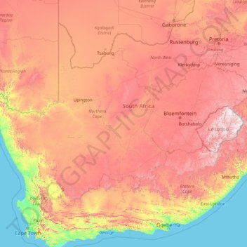
Name: Orange River topographic map, elevation, terrain.
Location: Orange River, South Africa (-30.69413 16.44945 -28.03360 29.07203)
Average elevation: 966 m
Minimum elevation: 0 m
Maximum elevation: 3,373 m
Make a donation
Other topographic maps
Click on a map to view its topography, its elevation and its terrain.
Cape Town
South Africa > Western Cape > City of Cape Town
The Cape Peninsula is 52 km long from Mouille Point in the north to Cape Point in the south, with an area of about 470 km2, and it displays more topographical variety than other similar sized areas in southern Africa, and consequently spectacular scenery. There are diverse low-nutrient soils, large rocky…
Average elevation: 53 m
Thohoyandou
South Africa > Limpopo > Vhembe District Municipality > Thulamela Local Municipality
Average elevation: 632 m
Pretoria
South Africa > Gauteng > City of Tshwane Metropolitan Municipality
Pretoria is situated approximately 55 km (34 mi) north-northeast of Johannesburg in the northeast of South Africa, in a transitional belt between the plateau of the Highveld to the south and the lower-lying Bushveld to the north. It lies at an altitude of about 1,339 m (4,393 ft) above sea level, in a warm,…
Average elevation: 1,363 m
Umlazi
South Africa > KwaZulu-Natal > eThekwini Metropolitan Municipality
Umlazi is situated on a series of undulating hills at an average elevation of 101 metres above sea level between the uMlaza River to the north and the uMbokodweni River to the south. Another river running through Umlazi is the Siphingo River which also runs towards the south of the township.
Average elevation: 100 m
Make a donation
Malamulele
South Africa > Limpopo > Vhembe District Municipality > Thulamela Local Municipality
Average elevation: 542 m
Make a donation
Johannesburg
South Africa > Gauteng > City of Johannesburg Metropolitan Municipality
Johannesburg is located in the eastern plateau area of South Africa known as the Highveld, at an elevation of 1,753 metres (5,751 ft). The former Central Business District is located on the southern side of the prominent ridge called the Witwatersrand (English: White Water's Ridge) and the terrain falls to the…
Average elevation: 1,615 m
Thembisa
South Africa > Gauteng > City of Ekurhuleni Metropolitan Municipality
Average elevation: 1,594 m
Cape Town
South Africa > Western Cape > City of Cape Town
The Cape Peninsula is 52 km long from Mouille Point in the north to Cape Point in the south, with an area of about 470 km2, and it displays more topographical variety than other similar sized areas in southern Africa, and consequently spectacular scenery. There are diverse low-nutrient soils, large rocky…
Average elevation: 53 m
Make a donation
Soweto
South Africa > Gauteng > City of Johannesburg Metropolitan Municipality
Average elevation: 1,638 m
Mashamba
South Africa > Limpopo > Vhembe District Municipality > Makhado Local Municipality
Average elevation: 587 m
Bronkhorstspruit
South Africa > Gauteng > City of Tshwane Metropolitan Municipality
Average elevation: 1,411 m
Chatsworth
South Africa > KwaZulu-Natal > eThekwini Metropolitan Municipality
Average elevation: 149 m
Make a donation
KuGompo City
South Africa > Eastern Cape > Buffalo City Metropolitan Municipality
Average elevation: 72 m
Mamelodi
South Africa > Gauteng > City of Tshwane Metropolitan Municipality
Average elevation: 1,319 m
Sebokeng
South Africa > Gauteng > Sedibeng District Municipality > Emfuleni Local Municipality
Average elevation: 1,523 m
Make a donation
Burgersfort
South Africa > Limpopo > Sekhukhune District Municipality > Greater Tubatse Local Municipality
Average elevation: 810 m
Sabie
South Africa > Mpumalanga > Ehlanzeni District Municipality > Thaba Chweu Local Municipality
Average elevation: 1,150 m
Johannesburg
South Africa > Gauteng > City of Johannesburg Metropolitan Municipality
Johannesburg is located in the eastern plateau area of South Africa known as the Highveld, at an elevation of 1,753 metres (5,751 ft). The former Central Business District is located on the southern side of the prominent ridge called the Witwatersrand (English: White Water's Ridge) and the terrain falls to the…
Average elevation: 1,615 m
Make a donation
Phuthaditjhaba
South Africa > Free State > Thabo Mofutsanyana District Municipality > Maluti-a-Phofung Local Municipality
Average elevation: 1,736 m
Make a donation
Stellenbosch
South Africa > Western Cape > Cape Winelands District Municipality > Stellenbosch Local Municipality
Stellenbosch is 53 km (33 mi) east of Cape Town via National Route N1. Stellenbosch is in a hilly region of the Cape Winelands, and is sheltered in a valley at an average elevation of 136 m (446 ft), flanked on the west by Papegaaiberg (Afrikaans: Parrot Mountain), which is actually a hill. To the south is…
Average elevation: 287 m
Nigel
South Africa > Gauteng > City of Ekurhuleni Metropolitan Municipality
Average elevation: 1,570 m
Sandton
South Africa > Gauteng > City of Johannesburg Metropolitan Municipality
Average elevation: 1,583 m
Make a donation
Evaton
South Africa > Gauteng > Sedibeng District Municipality > Emfuleni Local Municipality
Average elevation: 1,522 m
Giyani
South Africa > Limpopo > Mopani District Municipality > Greater Giyani Local Municipality
Average elevation: 481 m
Tzaneen
South Africa > Limpopo > Mopani District Municipality > Greater Tzaneen Local Municipality
Average elevation: 737 m
Umdloti / eMdloti
South Africa > KwaZulu-Natal > eThekwini Metropolitan Municipality
eMdloti has a permanent population of around 3,000 people but can increase by as much as tenfold during the Christmas and Easter holiday season. Due to eMdloti's single access road (M27) from the M4/N2 interchanges, the topography, the fact that North and South Beach Roads are both cul-de-sacs and limited…
Average elevation: 38 m
Make a donation
Hartbeespoort Dam
South Africa > North West > Bojanala Platinum District Municipality > Madibeng Local Municipality > Kosmos
Average elevation: 1,254 m
Make a donation
Jeffreys Bay
South Africa > Eastern Cape > Sarah Baartman District Municipality > Kouga Local Municipality
Average elevation: 30 m
Midrand
South Africa > Gauteng > City of Johannesburg Metropolitan Municipality
Average elevation: 1,542 m
Table Mountain
South Africa > Western Cape > City of Cape Town > Cape Town
Table Mountain is at the northern end of a sandstone mountain range that forms the spine of the Cape Peninsula that terminates approximately 50 kilometres (30 mi) to the south at the Cape of Good Hope and Cape Point. Immediately to the south of Table Mountain is a rugged "plateau" at a somewhat lower elevation…
Average elevation: 583 m
Make a donation
Roodepoort
South Africa > Gauteng > City of Johannesburg Metropolitan Municipality
Average elevation: 1,593 m
Vaal Dam
South Africa > Free State > Fezile Dabi District Municipality > Metsimaholo Local Municipality > Deneysville
Average elevation: 1,481 m
Letsitele
South Africa > Limpopo > Mopani District Municipality > Greater Tzaneen Local Municipality
Average elevation: 562 m
Malamulele
South Africa > Limpopo > Vhembe District Municipality > Thulamela Local Municipality
Average elevation: 542 m
Make a donation
Rustenburg
South Africa > North West > Bojanala Platinum District Municipality
Rustenburg has a humid subtropical climate (Köppen Cwa), with a relatively high degree of diurnal temperature variation due to the high elevation. It has very warm summers (from December to February) and mild winters (from June to August). Due to the altitude, summers are not quite as hot as one might expect.…
Average elevation: 1,217 m
Howick
South Africa > KwaZulu-Natal > uMgungundlovu District Municipality > uMgeni Local Municipality
Howick is possibly the location of the first crewed flight in the world. Evidence exists that a John Goodman Household flew a self made glider in 1871 and again in 1875 on the outskirts of Howick, close to Karkloof. The actual distance flown and altitude achieved differs from source to source (some sources say…
Average elevation: 1,066 m
Pongola
South Africa > KwaZulu-Natal > Zululand District Municipality > uPhongolo Local Municipality
Average elevation: 291 m
Middelburg
South Africa > Mpumalanga > Nkangala > Steve Tshwete Local Municipality
Average elevation: 1,493 m
Make a donation
Kempton Park
South Africa > Gauteng > City of Ekurhuleni Metropolitan Municipality
Average elevation: 1,654 m
Daveyton
South Africa > Gauteng > City of Ekurhuleni Metropolitan Municipality
Average elevation: 1,613 m
Lusikisiki
South Africa > Eastern Cape > O.R. Tambo District Municipality > Ingquza Hill Local Municipality
Average elevation: 563 m
Make a donation
Ga-Masemola
South Africa > Limpopo > Sekhukhune District Municipality > Makhuduthamaga Local Municipality
Average elevation: 911 m
Gqeberha
South Africa > Eastern Cape > Nelson Mandela Bay Metropolitan Municipality
Average elevation: 37 m
Pietermaritzburg
South Africa > KwaZulu-Natal > uMgungundlovu District Municipality
Average elevation: 853 m
Franschhoek
South Africa > Western Cape > Cape Winelands District Municipality > Stellenbosch Local Municipality
Average elevation: 502 m
Make a donation
Butterworth
South Africa > Eastern Cape > Amathole District Municipality > Mnquma Local Municipality
Average elevation: 599 m
Bloemfontein
South Africa > Free State > Mangaung Metropolitan Municipality
Situated at an elevation of 1,395 m (4,577 ft) above sea level, the city is home to approximately 520,000 residents and forms part of the Mangaung Metropolitan Municipality which has a population of 747,431. It was one of the host cities for the 2010 FIFA World Cup.
Average elevation: 1,374 m
Hazyview
South Africa > Mpumalanga > Ehlanzeni District Municipality > Mbombela
Average elevation: 554 m
Brits
South Africa > North West > Bojanala Platinum District Municipality > Madibeng Local Municipality
Average elevation: 1,120 m
Make a donation
Mbhokota Village
South Africa > Limpopo > Vhembe District Municipality > Makhado Local Municipality
Average elevation: 792 m
Ulundi
South Africa > KwaZulu-Natal > Zululand District Municipality > Ulundi Local Municipality
Average elevation: 586 m
Dzanani
South Africa > Limpopo > Vhembe District Municipality > Makhado Local Municipality
Average elevation: 833 m
Make a donation
Klapmuts
South Africa > Western Cape > Cape Winelands District Municipality > Stellenbosch Local Municipality
Average elevation: 186 m
Groblersdal
South Africa > Limpopo > Sekhukhune District Municipality > Elias Motsoaledi Local Municipality
Average elevation: 939 m
Van Wyksvlei
South Africa > Northern Cape > Pixley ka Seme District Municipality > Kareeberg Local Municipality
Average elevation: 974 m
Make a donation
Mbombela (Nelspruit)
South Africa > Mpumalanga > Ehlanzeni District Municipality
Average elevation: 842 m
Port Shepstone
South Africa > KwaZulu-Natal > Ugu District Municipality > Hibiscus Coast Local Municipality
Port Shepstone's topography is characterised by a rugged/hilly terrain with the Central Business District (CBD) lying on a large hill overlooking the Indian Ocean. Port Shepstone proper (excluding its extensions) is bordered by the uMzimkhulu River to the north and the N2 freeway to the east and is also…
Average elevation: 33 m
Hillcrest
South Africa > KwaZulu-Natal > eThekwini Metropolitan Municipality
Hillcrest is situated in the Upper Highway Area of Durban, approximately 32 kilometres (20 mi) north-west of the city and is bordered by Gillitts and Everton to the east, Waterfall to the north-east and Botha's Hill and Assagay to the north-west. It lies at an altitude of approximately 680 m (2231 ft) above…
Average elevation: 625 m
Make a donation
Vanderbijlpark
South Africa > Gauteng > Sedibeng District Municipality > Emfuleni Local Municipality
Vanderbijlpark is situated on the highveld of South Africa, at an altitude of 1,500 meters on the banks of the Vaal River. Summers in the city are warm to hot with an average high between 31 and 35°C, and an average low between 15 and 22°C. Winters in the city are cool to warm with an average high of between…
Average elevation: 1,474 m
Benoni
South Africa > Gauteng > City of Ekurhuleni Metropolitan Municipality
Average elevation: 1,645 m
Kriel
South Africa > Mpumalanga > Nkangala > Emalahleni Local Municipality
Hot summers and very cold winters. Rainfall approximately 660 mm per annum. Altitude 1598 m above sea level.
Average elevation: 1,569 m
Make a donation
Bizana
South Africa > Eastern Cape > Alfred Nzo District Municipality > Mbizana Local Municipality
Average elevation: 823 m
Mahikeng
South Africa > North West > Ngaka Modiri Molema District Municipality
Close to South Africa's border with Botswana, Mafikeng is 1,400 km (870 mi) northeast of Cape Town and 260 km (160 mi) west of Johannesburg. In 2001 it had a population of 49,300. In 2007 Mafikeng was reported to have a population of 250,000, of which the CBD constituted between 69,000 and 75,000. It is built…
Average elevation: 1,321 m
Cooper's Cave
South Africa > Gauteng > West Rand District Municipality > Krugersdorp
Average elevation: 1,479 m
Make a donation
Khowa (Elliot)
South Africa > Eastern Cape > Chris Hani District Municipality > Sakhisizwe Local Municipality
Average elevation: 1,497 m
Hlabisa
South Africa > KwaZulu-Natal > Umkhanyakude District Municipality > Hlabisa Local Municipality
Average elevation: 482 m
Manyii
South Africa > Limpopo > Vhembe District Municipality > Makhado Local Municipality
Average elevation: 912 m
Stanger / KwaDukuza
South Africa > KwaZulu-Natal > iLembe District Municipality > KwaDukuza Local Municipality
Average elevation: 96 m
Make a donation
Lenasia
South Africa > Gauteng > City of Johannesburg Metropolitan Municipality
Average elevation: 1,590 m
Kloof
South Africa > KwaZulu-Natal > eThekwini Metropolitan Municipality
The further subdivisions and sale of portions of Richmond Farm No. 999 by the Field heirs after 1901 resulted in the birth of Kloof as a residential area: numerous plots were sold to wealthy Durban residents and businessmen, who built country house retreats close to the city, but (due to its 550 m above sea…
Average elevation: 480 m
Bethlehem
South Africa > Free State > Thabo Mofutsanyana District Municipality > Dihlabeng Local Municipality
The city lies at an altitude of 1,700 metres (5,600 ft) and this contributes to its cool climate with frosty winters and mild summers. The average annual temperature is around 14 °C (57 °F).
Average elevation: 1,675 m
Make a donation
Empangeni
South Africa > KwaZulu-Natal > King Cetswayo District Municipality > uMhlathuze Local Municipality
Average elevation: 89 m
Tzaneen
South Africa > Limpopo > Mopani District Municipality > Greater Tzaneen Local Municipality
Average elevation: 737 m
Mdantsane
South Africa > Eastern Cape > Buffalo City Metropolitan Municipality
Average elevation: 264 m
Make a donation
Lebowakgomo
South Africa > Limpopo > Capricorn District Municipality > Lepelle-Nkumpi Local Municipality
Average elevation: 1,017 m
Thyspunt
South Africa > Eastern Cape > Sarah Baartman District Municipality > Kouga Local Municipality
Average elevation: 82 m
Welkom
South Africa > Free State > Lejweleputswa District Municipality
Koppie Alleen is the only hill near Welkom and therefore is aptly named for its oddity. The terrain elevation above sea level is 1435 metres. The largest water catchment is the Sand River to the south-east of Welkom in Virginia's direction. Large saline pans such as Flamingo Pan and Theronia Pan are situated…
Average elevation: 1,341 m
Make a donation