
Africa topographic map
Click on the map to display elevation.
Africa
Africa's topography is a complex tapestry of plateaus, mountains, valleys, and deserts. The continent is dominated by vast plateaus, with elevations averaging around 1,000 meters (3,281 feet), especially prominent in the south and east. The Ethiopian Highlands, often referred to as the "Roof of Africa," rise to formidable heights, with peaks such as Ras Dejen reaching 4,550 meters (14,928 feet). The Great Rift Valley, a significant geological feature, stretches from the Red Sea down to Mozambique, creating deep depressions hosting some of Africa's largest lakes, including Lake Tanganyika and Lake Malawi, and marked by volcanic mountains such as Mount Kilimanjaro, Africa's highest point at 5,895 metres (19,341 ft) and Mount Kenya. In the northwest, the Atlas Mountains extend through Morocco, Algeria, and Tunisia, with Mount Toubkal standing as the range's highest point at 4,167 meters (13,671 feet). Contrasting these elevations, the Sahara Desert sprawls across North Africa, characterized by expansive sand dunes and rocky plateaus. The southern part of Africa includes the Kalahari Desert and the Drakensberg Mountains, which rise steeply from the plains. This diverse terrain influences the continent's climate, biodiversity, and human settlements.
About this map
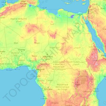
Name: Africa topographic map, elevation, terrain.
Location: Africa (-13.49757 -7.24219 36.50243 42.75781)
Average elevation: 462 m
Minimum elevation: -415 m
Maximum elevation: 4,436 m
Other topographic maps
Click on a map to view its topography, its elevation and its terrain.
South Africa
South Africa's topography is characterized by a high central plateau, known as the Highveld, which lies at elevations between 1,200 and 1,800 meters (3,937 to 5,906 feet) above sea level. This plateau is encircled by the Great Escarpment, a prominent mountainous feature that includes the Drakensberg Mountains,…
Average elevation: 221 m
Western Cape
The province is topographically exceptionally diverse. Most of the province falls within the Cape Fold Belt, a set of nearly parallel ranges of sandstone folded mountains of Cambrian-Ordovician age (the age of the rocks is from 510 to about 330 million years ago; their folding into mountains occurred about 350…
Average elevation: 90 m
Brunei
Average elevation: 100 m
KwaZulu-Natal
KwaZulu-Natal has a varied yet verdant climate thanks to diverse, complex topography. Generally, the coast is subtropical with inland regions becoming progressively colder. Durban on the south coast has an annual rainfall of 1009 mm, with daytime maxima peaking from January to March at 28 °C (82 °F) with a…
Average elevation: 777 m
Roodepoort
South Africa > Gauteng > City of Johannesburg Metropolitan Municipality
Average elevation: 1,593 m
KwaZulu-Natal
KwaZulu-Natal has a varied yet verdant climate thanks to diverse, complex topography. Generally, the coast is subtropical with inland regions becoming progressively colder. Durban on the south coast has an annual rainfall of 1009 mm, with daytime maxima peaking from January to March at 28 °C (82 °F) with a…
Average elevation: 950 m
Table Mountain
South Africa > Western Cape > City of Cape Town > Cape Town
Table Mountain is at the northern end of a sandstone mountain range that forms the spine of the Cape Peninsula that terminates approximately 50 kilometres (30 mi) to the south at the Cape of Good Hope and Cape Point. Immediately to the south of Table Mountain is a rugged "plateau" at a somewhat lower elevation…
Average elevation: 583 m
Henley Dam
South Africa > KwaZulu-Natal > uMgungundlovu District Municipality > Msunduzi Local Municipality
Average elevation: 976 m
Buffalo River
South Africa > Eastern Cape > Buffalo City Metropolitan Municipality > East London
Average elevation: 120 m
Melville Koppies
South Africa > Gauteng > City of Johannesburg Metropolitan Municipality > Johannesburg
Average elevation: 1,677 m
eThekwini Ward 97
South Africa > KwaZulu-Natal > eThekwini Metropolitan Municipality
Average elevation: 42 m
Vanderkloof Dam
South Africa > Northern Cape > Pixley ka Seme District Municipality > Renosterberg Local Municipality > Vanderkloof
Average elevation: 1,188 m
Komati River
The river originates west of Carolina, rising at an elevation of about 1,800 m (5,906 ft) near Breyten in the Ermelo district of the Mpumalanga province. It flows in a general northeasterly direction and reaches the Indian Ocean at Maputo Bay, after a course of some 800 km (497 mi).
Average elevation: 477 m
Mpumalanga
The Drakensberg escarpment divides Mpumalanga into a westerly half consisting mainly of high-altitude grassland called the Highveld and an eastern half situated in low-altitude subtropical Lowveld/Bushveld, mostly savanna habitat. The southern half of the Kruger National Park is in the latter region. The…
Average elevation: 1,127 m
Free State
The Free State is situated on a succession of flat grassy plains sprinkled with pastureland, resting on a general elevation of 3,800 feet only broken by the occasional hill or kopje. The rich soil and pleasant climate allow for a thriving agricultural industry. With more than 30,000 farms, which produce over…
Average elevation: 1,499 m
Orange River
The Orange rises in the Drakensberg mountains along the border between South Africa and Lesotho, about 193 km (120 mi) west of the Indian Ocean and at an altitude of over 3,000 m (9,800 ft). The extremity of the Orange River inside Lesotho is known as the Senqu. Parts of the Senqu River freeze in winter…
Average elevation: 966 m
Vaal Dam
South Africa > Free State > Fezile Dabi District Municipality > Metsimaholo Local Municipality > Deneysville
Average elevation: 1,481 m
Gauteng
Gauteng's southern border is the Vaal River, which separates it from the Free State. It also borders on North West to the west, Limpopo to the north, and Mpumalanga to the east. Gauteng is the only landlocked province of South Africa without a foreign border. Most of Gauteng is on the Highveld, a high-altitude…
Average elevation: 1,405 m
Bredasdorp
South Africa > Western Cape > Overberg District Municipality > Cape Agulhas Local Municipality
Bredasdorp is situated at an elevation of between 40 and 120 metres (130 and 390 ft) on the slopes of the Heuningberg (Afrikaans for "Honey Mountain"). There is no significant watercourse flowing through the town, although the Kars River flows past a few kilometres to the east.
Average elevation: 101 m
Rustenburg Local Municipality
South Africa > North West > Bojanala Platinum District Municipality
Average elevation: 1,287 m
Spioenkop Dam
South Africa > KwaZulu-Natal > Uthukela District Municipality > Okhahlamba Local Municipality
Average elevation: 1,139 m
Rhodes
South Africa > Eastern Cape > Joe Gqabi District Municipality > Senqu Local Municipality
Average elevation: 2,067 m
Cape Agulhas Local Municipality
South Africa > Western Cape > Overberg District Municipality
Average elevation: 120 m
Blyde River Canyon Nature Reserve
South Africa > Mpumalanga > Ehlanzeni District Municipality > Thaba Chweu Local Municipality
The Mogologolo (1,794 m), Mariepskop (1,944 m) and Hebronberg (1,767 m) massifs are partially included in the reserve. Elevation varies from 560 m to 1,944 m above sea level. Its resort areas are F.H. Odendaal and Swadeni, the latter only accessible from Limpopo province. The area of approximately 29,000…
Average elevation: 1,040 m
Verneukpan
South Africa > Northern Cape > Namakwa District Municipality > Hantam Local Municipality
Average elevation: 879 m
Umgeni River
South Africa > KwaZulu-Natal > eThekwini Metropolitan Municipality
Average elevation: 342 m
Kgetleng River Local Municipality
South Africa > North West > Bojanala Platinum District Municipality
Average elevation: 1,367 m
Bulwer Park
South Africa > KwaZulu-Natal > eThekwini Metropolitan Municipality > Durban
Average elevation: 59 m
Ramotshere Moiloa Local Municipality
South Africa > North West > Ngaka Modiri Molema District Municipality
Average elevation: 1,169 m
Durbanville
South Africa > Western Cape > City of Cape Town
Durbanville is situated in the northern suburbs of Cape Town, approximately 28 kilometres (17.4 mi) north-east of the city, bordered by Bellville to the south, Brackenfell to the south-east and Kraaifontein to the east. It lies at an altitude of between 100 m (328 ft) to 240 m (787 ft), in the vast rolling…
Average elevation: 157 m
Kimberley
South Africa > Northern Cape > Frances Baard District Municipality
Kimberley is set in a relatively flat landscape with no prominent topographic features within the urban limits. The only "hills" are debris dumps generated by more than a century of diamond mining. From the 1990s these were being recycled and poured back into De Beers Mine (by 2010 it was filled to within a…
Average elevation: 1,203 m
Malmesbury
South Africa > Western Cape > West Coast District Municipality > Swartland Local Municipality
Average elevation: 171 m
Roodeplaat Dam
South Africa > Gauteng > City of Tshwane Metropolitan Municipality
Average elevation: 1,240 m
Malgas Island Marine Protected Area
The type of rock of the reef is of some importance, as it influences the range of possibilities for the local topography, which in turn influences the range of habitats provided, and therefore the diversity of inhabitants. Sandstone and other sedimentary rocks erode and weather very differently, and depending…
Average elevation: 2 m
Ugu District Municipality
Being a coastal strip, the topography generally falls towards the coast and is segmented by many water courses (streams/rivers) resulting in numerous hills and valleys as well as very flat areas along the coast.
Average elevation: 458 m
Mangaung Ward 26
South Africa > Free State > Mangaung Metropolitan Municipality
Average elevation: 1,338 m
Kleinmond
South Africa > Western Cape > Overberg District Municipality > Overstrand Local Municipality
Average elevation: 119 m
Witklip Dam
South Africa > Mpumalanga > Ehlanzeni District Municipality > Thaba Chweu Local Municipality
Average elevation: 1,048 m
Sterkfontein Dam
South Africa > Free State > Thabo Mofutsanyana District Municipality > Maluti-a-Phofung Local Municipality
Average elevation: 1,748 m