
Montana topographic map
Interactive map
Click on the map to display elevation.
Montana
Montana's topography is marked by dramatic contrasts, offering a rich tapestry of landscapes. The state is divided into three main regions: the vast, rolling plains in the east, the rugged Rocky Mountains in the west, and the transition zone between these two. The eastern plains are part of the Great Plains, characterized by expansive grasslands, gently rolling hills, and wide river valleys, with minimal precipitation and semi-arid conditions. These plains are interrupted by isolated mountain ranges such as the Bear Paw and Little Rocky Mountains. The western part of the state is dominated by the Rocky Mountains, featuring steep, forested slopes, narrow valleys, and high peaks, including Granite Peak, which rises to 12,807 feet ((3,904 meters). Here, snow-covered mountains, active glaciers, and clear, cold lakes are common, particularly in areas like Glacier National Park. Between these extremes, the Central Front forms a transitional landscape with prairies, badlands, and smaller mountain ranges, bridging the plains and the mountains.
About this map
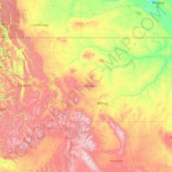
Name: Montana topographic map, elevation, terrain.
Location: Montana, United States (44.35792 -116.04923 49.00111 -104.03956)
Average elevation: 1,357 m
Minimum elevation: 552 m
Maximum elevation: 4,034 m
Other topographic maps
Click on a map to view its topography, its elevation and its terrain.
Sentinel
United States > Arizona > Maricopa County
Sentinel is an unincorporated community in Maricopa County, Arizona, United States. It has an estimated elevation of 692 feet (211 m) above sea level.
Average elevation: 213 m
Pine Neck
United States > New York > Suffolk County > East Quogue > Town of Southampton
Average elevation: 4 m
Westwood
United States > California > Lassen County > Westwood
Westwood is a census-designated place (CDP) in Lassen County, California, United States. Westwood is located 20 miles (32 km) west-southwest of Susanville, at an elevation of 5,128 feet (1,563 m). Its population is 1,541 as of the 2020 census, down from 1,647 from the 2010 census..
Average elevation: 1,577 m
Butterworth Farms
United States > New Jersey > Morris County > Morris Township
Average elevation: 182 m
Three Sisters
United States > Arizona > Navajo County
The area is part of the Colorado Plateau. The elevation of the valley floor ranges from 5,000 to 6,000 feet (1,500 to 1,800 m) above sea level. The floor is largely siltstone of the Cutler Group, or sand derived from it, deposited by the meandering rivers that carved the valley. The valley's vivid red color…
Average elevation: 1,664 m
Flagstaff
United States > Arizona > Coconino County
Flagstaff is the county seat of Coconino County. According to the United States Census Bureau, the city has a total area of 63.9 square miles (165.5 km2), of which only 0.03 square miles (0.08 km2) (0.08%) is water. Flagstaff lies at approximately 7,000 feet (2,130 m) elevation, and is surrounded by the…
Average elevation: 2,176 m
Delmont Place
United States > Louisiana > East Baton Rouge Parish > Baton Rouge
Average elevation: 20 m
Middleburg
United States > Virginia > Loudoun County
According to the United States Census Bureau, the town has a total area of 0.6 square mile (1.5 km2), all land. The elevation is 486 feet.
Average elevation: 144 m
Lights Dam
United States > Pennsylvania > Lebanon County > North Lebanon Township > Ebenezer
Average elevation: 168 m
Prunedale
United States > California > Monterey County
Prunedale is a unincorporated community in Monterey County, California, United States. It is located 8 miles (13 km) north of Salinas at an elevation of 92 feet (28 m). The population was 18,885 as of the 2020 census, up from 17,560 in 2010. For statistical purposes, the United States Census Bureau has defined…
Average elevation: 69 m
Lodi
United States > California > Lodi
Lodi is flat terrain at an elevation of approximately 50 feet (15 m) above mean sea level datum. Historically the area has had some grazing land uses as well as grain production.
Average elevation: 3 m
Fort Irwin
United States > California > San Bernardino County
Fort Irwin National Training Center (Fort Irwin NTC) is a major training area for the United States military in the Mojave Desert in northern San Bernardino County, California. Fort Irwin is at an average elevation of 2,454 feet (748 m). It is located 37 miles (60 km) northeast of Barstow, in the Calico…
Average elevation: 785 m