
Make a donation
Maine topographic map
Click on the map to display elevation.
Make a donation
Maine
Maine's topography is characterized by a diverse range of landscapes, from its rugged coastline to its mountainous interiors. The state is bordered by the Atlantic Ocean to the southeast, which features a mix of low-lying sandy beaches and rocky cliffs. Inland, the terrain transitions into rolling hills and flat plateaus, particularly prominent in the Aroostook County region known for its agricultural productivity. The western part of Maine is dominated by the Appalachian Mountains, including Mount Katahdin, the highest peak in the state at 5,267 feet (1,605 meters). This mountainous terrain is accompanied by a series of lakes, such as Moosehead and Sebago, and an extensive network of rivers and streams, adding to the intricate hydrology of the region. The average elevation of Maine is around 600 feet (183 meters), with significant variations throughout the state, showcasing a blend of coastal lowlands and elevated uplands that reflect the effects of glacial activity from the last ice age.
Make a donation
About this map
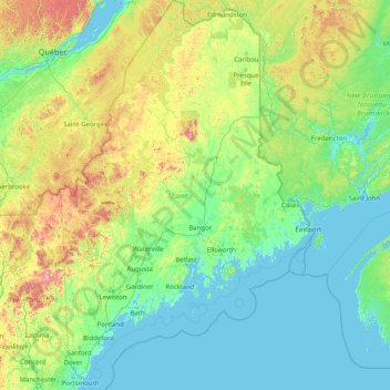
Name: Maine topographic map, elevation, terrain.
Location: Maine, United States (42.92222 -71.08417 47.45984 -66.88541)
Average elevation: 198 m
Minimum elevation: -3 m
Maximum elevation: 1,893 m
Make a donation
Other topographic maps
Click on a map to view its topography, its elevation and its terrain.
Harbour Town
United States > South Carolina > Beaufort County > Hilton Head Island
Average elevation: 2 m
Middleburg
United States > Virginia > Loudoun County
According to the United States Census Bureau, the town has a total area of 0.6 square mile (1.5 km2), all land. The elevation is 486 feet.
Average elevation: 144 m
Make a donation
Make a donation
Make a donation
Make a donation
Make a donation
Make a donation
Make a donation
Make a donation
Make a donation
Flagstaff
United States > Arizona > Coconino County
Flagstaff is the county seat of Coconino County. According to the United States Census Bureau, the city has a total area of 63.9 square miles (165.5 km2), of which only 0.03 square miles (0.08 km2) (0.08%) is water. Flagstaff lies at approximately 7,000 feet (2,130 m) elevation, and is surrounded by the…
Average elevation: 2,176 m
Make a donation
Butterworth Farms
United States > New Jersey > Morris County > Morris Township
Average elevation: 182 m
Westwood
United States > California > Lassen County > Westwood
Westwood is a census-designated place (CDP) in Lassen County, California, United States. Westwood is located 20 miles (32 km) west-southwest of Susanville, at an elevation of 5,128 feet (1,563 m). Its population is 1,541 as of the 2020 census, down from 1,647 from the 2010 census..
Average elevation: 1,577 m
Make a donation
Pine Neck
United States > New York > Suffolk County > East Quogue > Town of Southampton
Average elevation: 4 m
Make a donation
Bozeman
United States > Montana > Gallatin County > Bozeman
Bozeman is located at an elevation of 4,820 feet (1,470 m). The Bridger Mountains are to the north-northeast, the Tobacco Root Mountains to the west-south-west, the Big Belt Mountains and Horseshoe Hills to the northwest, the Hyalite Peaks of the northern Gallatin Range to the south and the Spanish Peaks of…
Average elevation: 1,679 m
Prunedale
United States > California > Monterey County
Prunedale is a unincorporated community in Monterey County, California, United States. It is located 8 miles (13 km) north of Salinas at an elevation of 92 feet (28 m). The population was 18,885 as of the 2020 census, up from 17,560 in 2010. For statistical purposes, the United States Census Bureau has defined…
Average elevation: 69 m
Make a donation
Make a donation
Make a donation
Delmont Place
United States > Louisiana > East Baton Rouge Parish > Baton Rouge
Average elevation: 20 m
Make a donation
Make a donation
Three Sisters
United States > Arizona > Navajo County
The area is part of the Colorado Plateau. The elevation of the valley floor ranges from 5,000 to 6,000 feet (1,500 to 1,800 m) above sea level. The floor is largely siltstone of the Cutler Group, or sand derived from it, deposited by the meandering rivers that carved the valley. The valley's vivid red color…
Average elevation: 1,664 m
Make a donation
Make a donation
Make a donation
Make a donation
Make a donation
Make a donation
Fort Irwin
United States > California > San Bernardino County
Fort Irwin National Training Center (Fort Irwin NTC) is a major training area for the United States military in the Mojave Desert in northern San Bernardino County, California. Fort Irwin is at an average elevation of 2,454 feet (748 m). It is located 37 miles (60 km) northeast of Barstow, in the Calico…
Average elevation: 785 m
Make a donation
Lodi
United States > California > Lodi
Lodi is flat terrain at an elevation of approximately 50 feet (15 m) above mean sea level datum. Historically the area has had some grazing land uses as well as grain production.
Average elevation: 3 m
Make a donation