
Make a donation
New Ferry topographic map
Click on the map to display elevation.
Make a donation
New Ferry
New Ferry is on the eastern side of the Wirral Peninsula, on the western bank of the River Mersey. The area is approximately 9 km (5.6 mi) south-south-east of the Irish Sea at New Brighton and about 10 km (6.2 mi) east-north-east of the Dee Estuary at Heswall. The area lies at an elevation of between 0–27 m (0–89 ft) above sea level.
Make a donation
About this map
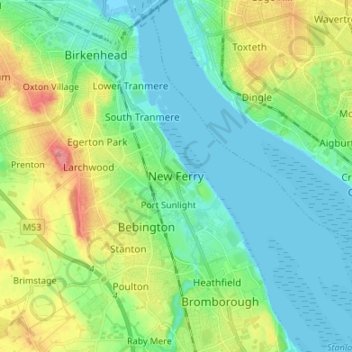
Name: New Ferry topographic map, elevation, terrain.
Average elevation: 25 m
Minimum elevation: -2 m
Maximum elevation: 84 m
Make a donation
Other topographic maps
Click on a map to view its topography, its elevation and its terrain.
Make a donation
Make a donation
Dartmoor National Park
United Kingdom > England > Devon
Rainfall tends to be associated with Atlantic depressions or with convection. In summer, convection caused by solar surface heating sometimes forms shower clouds and a large proportion of rainfall comes from showers and thunderstorms at this time of year. The wettest months are November and December and on the…
Average elevation: 239 m
Make a donation
Make a donation
Exeter
United Kingdom > England > Devon
The city of Exeter was established on the eastern bank of the River Exe on a ridge of land backed by a steep hill. It is at this point that the Exe, having just been joined by the River Creedy, opens onto a wide flood plain and estuary which results in quite common flooding. Historically this was the lowest…
Average elevation: 56 m
Christchurch
United Kingdom > England > Bournemouth, Christchurch and Poole > Hurn
Average elevation: 18 m
Make a donation
Ipswich
United Kingdom > England > Suffolk
Ipswich experiences an oceanic climate, like the rest of the British Isles, with a narrow range of temperature and rainfall spread evenly throughout the year. One of the two nearest for which data is available is East Bergholt, about 7 miles (11 km) south west of the town centre and at a similar elevation, and…
Average elevation: 29 m
Make a donation
Bilsthorpe CP
United Kingdom > England > Nottinghamshire > Newark and Sherwood
Average elevation: 75 m
Make a donation
Make a donation
Make a donation
Medstead
United Kingdom > England > Hampshire > East Hampshire
Medstead is a village and civil parish in the East Hampshire district of Hampshire, England. Its nearest town is Alton, which lies 4.3 miles (6.9 km) northeast of the village. According to the 2011 census, the village had a population of 2,036 people. The parish covers an area of 1,536 acres (622 ha) and has…
Average elevation: 186 m
Make a donation
Make a donation
Make a donation
Make a donation
Make a donation
Make a donation
Make a donation
Kingston upon Hull
Kingston upon Hull is on the northern bank of the Humber Estuary. The city centre is west of the River Hull and close to the Humber. The city is built upon alluvial and glacial deposits which overlie chalk rocks but the underlying chalk has no influence on the topography. The land within the city is generally…
Average elevation: 3 m
Make a donation
Make a donation
Northampton
United Kingdom > England > West Northamptonshire
As with the rest of the British Isles, Northampton experiences an oceanic climate with cool summers and mild winters. The official Met Office weather station for Northampton is the Moulton Park Weather Station at the University of Northampton. Situated at an elevation of around 130 m (427 ft) above sea level…
Average elevation: 89 m
Make a donation
Spring Gardens
United Kingdom > England > Bath and North East Somerset > Reading
Average elevation: 47 m
Make a donation
Yorkshire
In Yorkshire there is a very close relationship between the major topographical areas and the geological period in which they were formed. The Pennine chain of hills in the west is of Carboniferous origin. The central vale is Permo-Triassic. The North York Moors in the north-east of the county are Jurassic in…
Average elevation: 130 m
Make a donation
Sunningdale
United Kingdom > England > Royal Borough of Windsor and Maidenhead
Average elevation: 61 m
Woodhurst
United Kingdom > England > Cambridgeshire > Huntingdonshire > Woodhurst
Average elevation: 31 m
Make a donation
Warminster
United Kingdom > England > Wiltshire
Warminster Town Hall, at the junction of the High Street and Weymouth Street, was designed c. 1837 by Edward Blore at the expense of the 5th Marquess of Bath; the two-storey front elevation is a replica of Longleat, with the addition of a central bellcote, clock and coat of arms. The building was sold by the…
Average elevation: 143 m
Make a donation
Reading
Jane Austen attended Reading Ladies Boarding School, based in the Abbey Gateway, in 1784–1786. Mary Russell Mitford lived in Reading for a number of years and then spent the rest of her life just outside the town at Three Mile Cross and Swallowfield. The fictional Belford Regis of her eponymous novel, first…
Average elevation: 54 m
Make a donation
Godmanchester
United Kingdom > England > Cambridgeshire > Huntingdonshire > Godmanchester
Average elevation: 22 m
Make a donation